|
|
|
Specific Water Well Detail |
|
|
| Location Info | |||
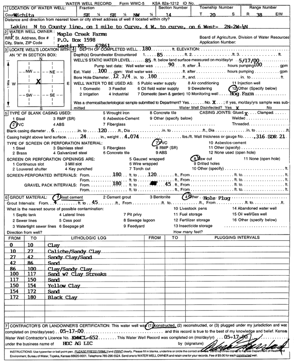
| Owner: Maple Creek Farms | Status: Constructed | ||
| Location: T20S, R38W, Sec. 14, SE SE NW | County: Wichita | ||
| Directions: from Lakin: N to county line, 1 mi to curve, 10 W, 2 N, 2 W, .25 N | |||
| Latitude: 38.3150879 | Longitude: -101.485262 | Datum NAD 27 | |
| Latitude: 38.3151056 | Longitude: -101.4857053 | Datum NAD 83 | |
| Longitude and latitude calculated by Survey from township-range-section-quarter calls. Only good to within the quarter call accuracy. | |||
| View well on interactive map | |||
| General Info | ||
| Well Depth: 180 ft. | Elevation: ft. | |
| Static Water Level: 85 ft. | Est. Yield: 100 gpm. | |
| Comp. Date: 17-May-2000 | Well Use: Feedlot | |
| DWR Applic. #: | Other ID: | |
| Links | |
| No Wizard information available. | |
| View info from WIMAS Water Right Data base... | |
| Driller Info | ||
| Driller: H.D.C. AG, LLC | License #: 652 | |
| Scanned Form | View scan |
|
Chemical Sample Submitted?:
Water Well disinfected?: | ||
| Casing Info | ||
| Casing Type:
Casing Joints: |
Diam: in. to ft | |
| Casing height above land surface: in
Casing Weight: lbs/ft Wall thickness or gauge no.: | ||
| Screen and Perforation Info | ||
| Screen Type: | Screen Openings: | |
| Screen-perforated intervals | From: ft to ft | |
| Gravel pack intervals | From: ft to ft | |
| Grout Info | ||
| Grout used: | From: to ft | |
| Source of Possible Contamination | ||
| Source: | ||
| Direction from well: | Distance: ft | |
| Lithologic Log
(Log data entered by KGS.) | ||
| From: 0 ft. to 10 ft. | Clay | |
| From: 10 ft. to 27 ft. | Caliche and sandy clay | |
| From: 27 ft. to 42 ft. | Sandy clay and sand | |
| From: 42 ft. to 86 ft. | Sand | |
| From: 86 ft. to 100 ft. | Clay and sandy clay | |
| From: 100 ft. to 117 ft. | Sand with clay streaks | |
| From: 117 ft. to 150 ft. | Sand | |
| From: 150 ft. to 154 ft. | Yellow clay | |
| From: 154 ft. to 172 ft. | Sand | |
| From: 172 ft. to 180 ft. | Black clay | |