|
|
|
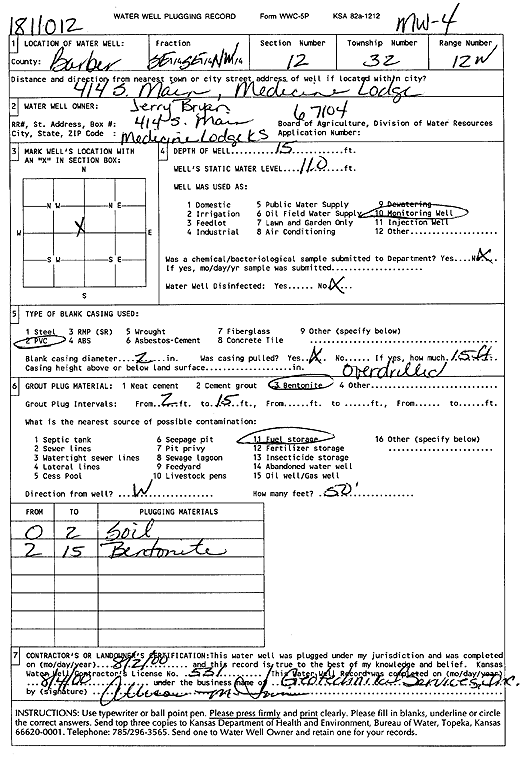
Specific Water Well Detail |
|
|
| Location Info | |||
| Owner: Bryan, Jerry | Status: Plugged | ||
| Location: T32S, R12W, Sec. 12, SE SE NW | County: Barber | ||
| Directions: 414 S Main, Medicine Lodge (id 1811012) | |||
| Latitude: 37.2767266 | Longitude: -98.5785196 | Datum NAD 27 | |
| Latitude: 37.2767495 | Longitude: -98.5788806 | Datum NAD 83 | |
| Longitude and latitude calculated by Survey from township-range-section-quarter calls. Only good to within the quarter call accuracy. | |||
| View well on interactive map | |||
| General Info | ||
| Well Depth: 15 ft. | Elevation: ft. | |
| Static Water Level: 11 ft. | Est. Yield: gpm. | |
| Comp. Date: 02-Aug-2000 | Well Use: Monitoring well/observation/piezometer | |
| DWR Applic. #: | Other ID: MW 4 | |
| Driller Info | ||
| Driller: Geotechnical Services, Inc. | License #: 531 | |
| Scanned Form | View scan |
| Casing Info | ||
|
Casing Type:
Diam: in. Casing height above land surface: in | ||
| Grout Info | ||
| Grout used: | From: to ft | |
| Source of Possible Contamination | ||
| Source: | ||
| Direction from well: | Distance: ft | |