|
|
|
Specific Water Well Detail |
|
|
| Location Info | |||
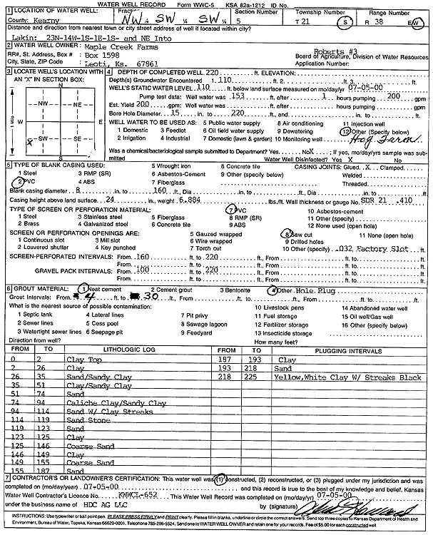
| Owner: Maple Creek Farms | Status: Constructed | ||
| Location: T21S, R38W, Sec. 5, NW SW SW | County: Kearny | ||
| Directions: from Lakin: 23 mi N, 14 mi W, 1 mi S, 1 mi E, 1 mi S, NE into site | |||
| Latitude: 38.2515527 | Longitude: -101.5229535 | Datum NAD 27 | |
| Latitude: 38.2515702 | Longitude: -101.5233979 | Datum NAD 83 | |
| Longitude and latitude calculated by Survey from township-range-section-quarter calls. Only good to within the quarter call accuracy. | |||
| View well on interactive map | |||
| General Info | ||
| Well Depth: 220 ft. | Elevation: ft. | |
| Static Water Level: 110 ft. | Est. Yield: 200 gpm. | |
| Comp. Date: 05-Jul-2000 | Well Use: Feedlot | |
| DWR Applic. #: | Other ID: Roberts 3 | |
| Driller Info | ||
| Driller: Alva Howard, H.D.C. AG, LLC | License #: 652 | |
| Scanned Form | View scan |
|
Chemical Sample Submitted?:
Water Well disinfected?: | ||
| Casing Info | ||
| Casing Type:
Casing Joints: |
Diam: in. to ft | |
| Casing height above land surface: in
Casing Weight: lbs/ft Wall thickness or gauge no.: | ||
| Screen and Perforation Info | ||
| Screen Type: | Screen Openings: | |
| Screen-perforated intervals | From: ft to ft | |
| Gravel pack intervals | From: ft to ft | |
| Grout Info | ||
| Grout used: | From: to ft | |
| Source of Possible Contamination | ||
| Source: | ||
| Direction from well: | Distance: ft | |
| Lithologic Log
(Log data entered by KGS.) | ||
| From: 0 ft. to 2 ft. | clay top | |
| From: 2 ft. to 26 ft. | clay | |
| From: 26 ft. to 35 ft. | sand, sandy clay | |
| From: 35 ft. to 51 ft. | clay, sandy clay | |
| From: 51 ft. to 74 ft. | sand | |
| From: 74 ft. to 94 ft. | caliche clay, sandy clay | |
| From: 94 ft. to 114 ft. | sand with clay streaks | |
| From: 114 ft. to 119 ft. | sandstone | |
| From: 119 ft. to 123 ft. | sand | |
| From: 123 ft. to 125 ft. | clay | |
| From: 125 ft. to 146 ft. | coarse sand | |
| From: 146 ft. to 149 ft. | clay | |
| From: 149 ft. to 155 ft. | coarse sand | |
| From: 155 ft. to 187 ft. | sand | |
| From: 187 ft. to 193 ft. | clay | |
| From: 193 ft. to 218 ft. | sand | |
| From: 218 ft. to 225 ft. | yellow, white clay with streaks black | |