|
|
|
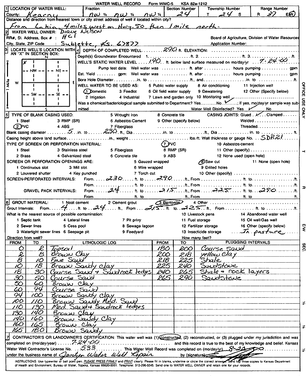
Specific Water Well Detail |
|
|
| Location Info | |||
| Owner: Nelson, Diane | Status: Constructed | ||
| Location: T24S, R37W, Sec. 24, NW NW NW | County: Kearny | ||
| Directions: from Lakin: 4 mi W on Hwy 50, 1 mi N | |||
| Latitude: 37.957715 | Longitude: -101.3386384 | Datum NAD 27 | |
| Latitude: 37.9577333 | Longitude: -101.3390859 | Datum NAD 83 | |
| Longitude and latitude calculated by Survey from township-range-section-quarter calls. Only good to within the quarter call accuracy. | |||
| View well on interactive map | |||
| General Info | ||
| Well Depth: 290 ft. | Elevation: ft. | |
| Static Water Level: 190 ft. | Est. Yield: gpm. | |
| Comp. Date: 24-Jul-2000 | Well Use: Domestic | |
| DWR Applic. #: | Other ID: | |
| Driller Info | ||
| Driller: Ed Jantzen Water Well Repair | License #: 533 | |
| Scanned Form | View scan |
|
Chemical Sample Submitted?:
Water Well disinfected?: | ||
| Casing Info | ||
| Casing Type:
Casing Joints: |
Diam: in. to ft | |
| Casing height above land surface: in
Casing Weight: lbs/ft Wall thickness or gauge no.: | ||
| Screen and Perforation Info | ||
| Screen Type: | Screen Openings: | |
| Screen-perforated intervals | From: ft to ft | |
| Gravel pack intervals | From: ft to ft | |
| Grout Info | ||
| Grout used: | From: to ft | |
| Source of Possible Contamination | ||
| Source: | ||
| Direction from well: | Distance: ft | |
| Lithologic Log
(Log data entered by KGS.) | ||
| From: 0 ft. to 2 ft. | top soil | |
| From: 2 ft. to 8 ft. | brown clay | |
| From: 8 ft. to 10 ft. | fine sand | |
| From: 10 ft. to 18 ft. | brown sandy clay | |
| From: 18 ft. to 30 ft. | coarse sand and sandrock ledges | |
| From: 30 ft. to 50 ft. | coarse sand | |
| From: 50 ft. to 60 ft. | brown clay | |
| From: 60 ft. to 94 ft. | coarse sand | |
| From: 94 ft. to 100 ft. | brown sandy clay | |
| From: 100 ft. to 110 ft. | brown sandy medium sand | |
| From: 110 ft. to 130 ft. | medium sand and sandrock ledges | |
| From: 130 ft. to 140 ft. | brown clay | |
| From: 140 ft. to 160 ft. | brown sandy clay | |
| From: 160 ft. to 165 ft. | brown clay | |
| From: 165 ft. to 180 ft. | brown sandy | |
| From: 180 ft. to 200 ft. | coarse sand | |
| From: 200 ft. to 218 ft. | yellow clay | |
| From: 218 ft. to 225 ft. | shale | |
| From: 225 ft. to 240 ft. | sandstone | |
| From: 240 ft. to 265 ft. | shale and rock layers | |
| From: 265 ft. to 290 ft. | sandstone | |