|
|
|
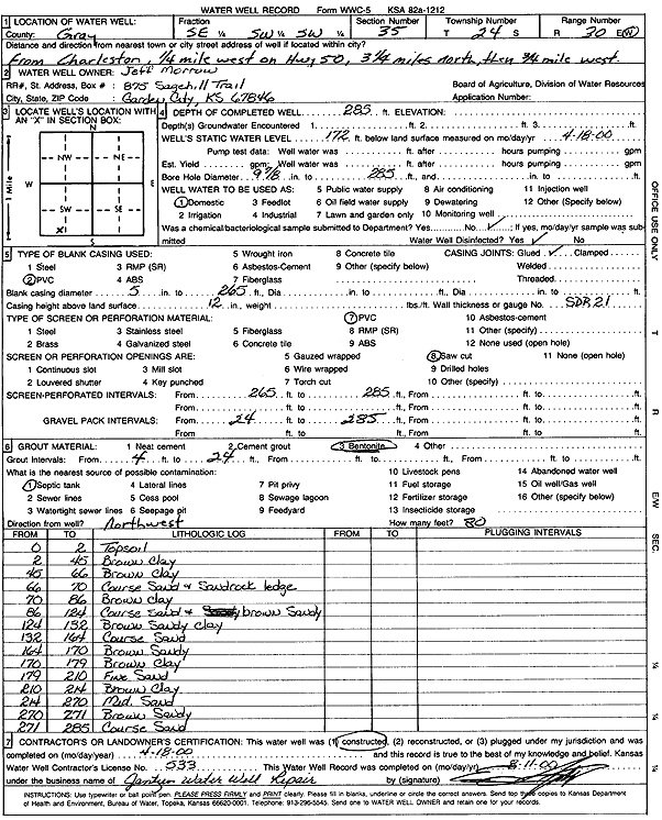
Specific Water Well Detail |
|
|
| Location Info | |||
| Owner: Morrow, Jeff | Status: Constructed | ||
| Location: T24S, R30W, Sec. 35, SE SW SW | County: Gray | ||
| Directions: from Charleston: .25 mi W on Hwy 50, 3.25 mi N, .75 mi W | |||
| Latitude: 37.9158724 | Longitude: -100.5879156 | Datum NAD 27 | |
| Latitude: 37.915894 | Longitude: -100.5883452 | Datum NAD 83 | |
| Longitude and latitude calculated by Survey from township-range-section-quarter calls. Only good to within the quarter call accuracy. | |||
| View well on interactive map | |||
| General Info | ||
| Well Depth: 285 ft. | Elevation: ft. | |
| Static Water Level: 172 ft. | Est. Yield: gpm. | |
| Comp. Date: 18-Apr-2000 | Well Use: Domestic | |
| DWR Applic. #: | Other ID: | |
| Driller Info | ||
| Driller: Ed Jantzen Water Well Repair | License #: 533 | |
| Scanned Form | View scan |
|
Chemical Sample Submitted?:
Water Well disinfected?: | ||
| Casing Info | ||
| Casing Type:
Casing Joints: |
Diam: in. to ft | |
| Casing height above land surface: in
Casing Weight: lbs/ft Wall thickness or gauge no.: | ||
| Screen and Perforation Info | ||
| Screen Type: | Screen Openings: | |
| Screen-perforated intervals | From: ft to ft | |
| Gravel pack intervals | From: ft to ft | |
| Grout Info | ||
| Grout used: | From: to ft | |
| Source of Possible Contamination | ||
| Source: | ||
| Direction from well: | Distance: ft | |
| Lithologic Log
(Log data entered by KGS.) | ||
| From: 0 ft. to 2 ft. | Topsoil | |
| From: 2 ft. to 45 ft. | Brown clay | |
| From: 45 ft. to 66 ft. | Brown clay | |
| From: 66 ft. to 70 ft. | Coarse Sand and Sandrock ledge | |
| From: 70 ft. to 86 ft. | Brown clay | |
| From: 86 ft. to 124 ft. | Coarse Sand and brown Sandy | |
| From: 124 ft. to 132 ft. | Brown sandy clay | |
| From: 132 ft. to 164 ft. | Coarse sand | |
| From: 164 ft. to 170 ft. | Brown Sandy | |
| From: 170 ft. to 179 ft. | Brown clay | |
| From: 179 ft. to 210 ft. | Fine Sand | |
| From: 210 ft. to 214 ft. | Brown Clay | |
| From: 214 ft. to 270 ft. | Medium Sand | |
| From: 270 ft. to 271 ft. | Brown Sandy | |
| From: 271 ft. to 285 ft. | Coarse Sand | |