|
|
|
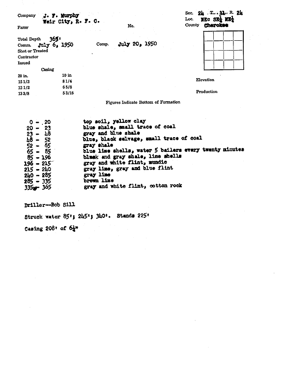
Specific Water Well Detail |
|
|
| Location Info | |||
| Owner: Weir City, R.F.C. | Status: Constructed | ||
| Location: T31S, R24E, Sec. 24, NE SE NE | County: Cherokee | ||
| Directions: | |||
| Latitude: 37.3341663 | Longitude: -94.7241783 | Datum NAD 27 | |
| Latitude: 37.3342199 | Longitude: -94.7244152 | Datum NAD 83 | |
| Longitude and latitude calculated by Survey from township-range-section-quarter calls. Only good to within the quarter call accuracy. | |||
| View well on interactive map | |||
| General Info | ||
| Well Depth: 365 ft. | Elevation: ft. | |
| Static Water Level: 225 ft. | Est. Yield: gpm. | |
| Comp. Date: 20-Jul-1950 | Well Use: (unstated)/abandoned | |
| DWR Applic. #: | Other ID: | |
| Driller Info | ||
| Driller: J.F. Murphy | License #: | |
| Scanned Form | View scan |
|
Chemical Sample Submitted?:
Water Well disinfected?: | ||
| Casing Info | ||
| Casing Type:
Casing Joints: |
Diam: in. to ft | |
| Casing height above land surface: in
Casing Weight: lbs/ft Wall thickness or gauge no.: | ||
| Screen and Perforation Info | ||
| Screen Type: | Screen Openings: | |
| Screen-perforated intervals | From: ft to ft | |
| Gravel pack intervals | From: ft to ft | |
| Grout Info | ||
| Grout used: | From: to ft | |
| Source of Possible Contamination | ||
| Source: | ||
| Direction from well: | Distance: ft | |
| Lithologic Log
(Log data entered by KGS.) | ||
| From: 0 ft. to 20 ft. | Top soil, yellow clay | |
| From: 20 ft. to 23 ft. | Blue shale, small trace of coal | |
| From: 23 ft. to 48 ft. | Gray and blue shale | |
| From: 48 ft. to 52 ft. | Blue, black selvage, small trace of coal | |
| From: 52 ft. to 65 ft. | Gray shale | |
| From: 65 ft. to 85 ft. | Blue lime shells, water 5 bailers every 20 minutes | |
| From: 85 ft. to 196 ft. | Black and gray shale, lime shells | |
| From: 196 ft. to 215 ft. | Gray and white flint, mundic | |
| From: 215 ft. to 240 ft. | Gray lime, gray and blue flint | |
| From: 240 ft. to 285 ft. | Gray lime | |
| From: 285 ft. to 335 ft. | Brown lime | |
| From: 335 ft. to 365 ft. | Gray and white flint, cotton rock | |