|
|
|
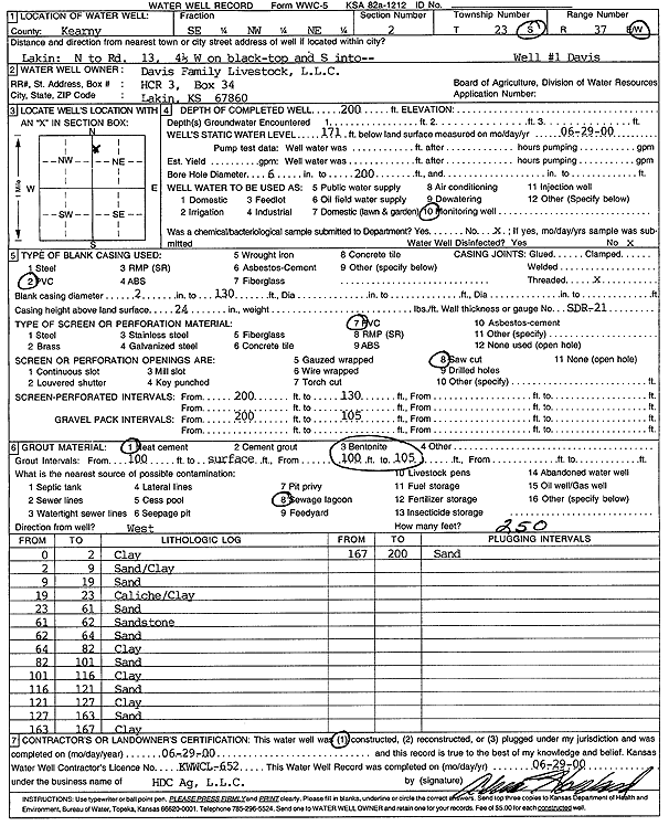
Specific Water Well Detail |
|
|
| Location Info | |||
| Owner: Davis Family Livestock L.L.C. | Status: Constructed | ||
| Location: T23S, R37W, Sec. 2, SE NW NE | County: Kearny | ||
| Directions: from Lakin: N to Rd 13, 4.5 mi W on black top, S into site | |||
| Latitude: 38.0872568 | Longitude: -101.3456486 | Datum NAD 27 | |
| Latitude: 38.0872758 | Longitude: -101.3460938 | Datum NAD 83 | |
| Longitude and latitude calculated by Survey from township-range-section-quarter calls. Only good to within the quarter call accuracy. | |||
| View well on interactive map | |||
| General Info | ||
| Well Depth: 200 ft. | Elevation: ft. | |
| Static Water Level: 171 ft. | Est. Yield: gpm. | |
| Comp. Date: 29-Jun-2000 | Well Use: Monitoring well/observation/piezometer | |
| DWR Applic. #: | Other ID: Well 1 Davis | |
| Driller Info | ||
| Driller: Alva Howard, H.D.C. AG, LLC | License #: 652 | |
| Scanned Form | View scan |
|
Chemical Sample Submitted?:
Water Well disinfected?: | ||
| Casing Info | ||
| Casing Type:
Casing Joints: |
Diam: in. to ft | |
| Casing height above land surface: in
Casing Weight: lbs/ft Wall thickness or gauge no.: | ||
| Screen and Perforation Info | ||
| Screen Type: | Screen Openings: | |
| Screen-perforated intervals | From: ft to ft | |
| Gravel pack intervals | From: ft to ft | |
| Grout Info | ||
| Grout used: | From: to ft | |
| Source of Possible Contamination | ||
| Source: | ||
| Direction from well: | Distance: ft | |
| Lithologic Log
(Log data entered by KGS.) | ||
| From: 0 ft. to 2 ft. | clay | |
| From: 2 ft. to 9 ft. | sand/clay | |
| From: 9 ft. to 19 ft. | sand | |
| From: 19 ft. to 23 ft. | caliche/clay | |
| From: 23 ft. to 61 ft. | sand | |
| From: 61 ft. to 62 ft. | sandstone | |
| From: 62 ft. to 64 ft. | sand | |
| From: 64 ft. to 82 ft. | clay | |
| From: 82 ft. to 101 ft. | sand | |
| From: 101 ft. to 116 ft. | sand | |
| From: 116 ft. to 121 ft. | sand | |
| From: 121 ft. to 127 ft. | clay | |
| From: 127 ft. to 163 ft. | sand | |
| From: 163 ft. to 167 ft. | clay | |
| From: 167 ft. to 200 ft. | sand | |