|
|
|
Specific Water Well Detail |
|
|
| Location Info | |||
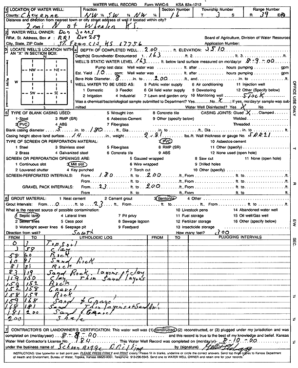
| Owner: Jones, Dan | Status: Constructed | ||
| Location: T3S, R39W, Sec. 16, NW SW NW | County: Cheyenne | ||
| Directions: from Wheeler, 2 mi N | |||
| Latitude: 39.795476 | Longitude: -101.7092923 | Datum NAD 27 | |
| Latitude: 39.7954693 | Longitude: -101.7097417 | Datum NAD 83 | |
| Longitude and latitude calculated by Survey from township-range-section-quarter calls. Only good to within the quarter call accuracy. | |||
| View well on interactive map | |||
| General Info | ||
| Well Depth: 200 ft. | Elevation: ft. | |
| Static Water Level: 163 ft. | Est. Yield: gpm. | |
| Comp. Date: 08-Aug-2000 | Well Use: Domestic, Livestock | |
| DWR Applic. #: | Other ID: | |
| Driller Info | ||
| Driller: Schoenrogge Drilling, Inc. | License #: 184 | |
| Scanned Form | View scan |
|
Chemical Sample Submitted?:
Water Well disinfected?: | ||
| Casing Info | ||
| Casing Type:
Casing Joints: |
Diam: in. to ft | |
| Casing height above land surface: in
Casing Weight: lbs/ft Wall thickness or gauge no.: | ||
| Screen and Perforation Info | ||
| Screen Type: | Screen Openings: | |
| Screen-perforated intervals | From: ft to ft | |
| Gravel pack intervals | From: ft to ft | |
| Grout Info | ||
| Grout used: | From: to ft | |
| Source of Possible Contamination | ||
| Source: | ||
| Direction from well: | Distance: ft | |
| Lithologic Log
(Log data entered by KGS.) | ||
| From: 0 ft. to 3 ft. | Topsoil | |
| From: 3 ft. to 58 ft. | Clay | |
| From: 58 ft. to 60 ft. | Rock | |
| From: 60 ft. to 81 ft. | Sand rock | |
| From: 81 ft. to 83 ft. | Rock | |
| From: 83 ft. to 119 ft. | Sand rock, layers of clay | |
| From: 119 ft. to 150 ft. | Clay, thin sand layers | |
| From: 150 ft. to 152 ft. | Rock | |
| From: 152 ft. to 158 ft. | Gravel | |
| From: 158 ft. to 159 ft. | Rock | |
| From: 159 ft. to 168 ft. | Sand and gravel | |
| From: 168 ft. to 181 ft. | Sand, thin layers of sand rock | |
| From: 181 ft. to 200 ft. | Sand and gravel | |
| From: 200 ft. to ft. | Shale | |