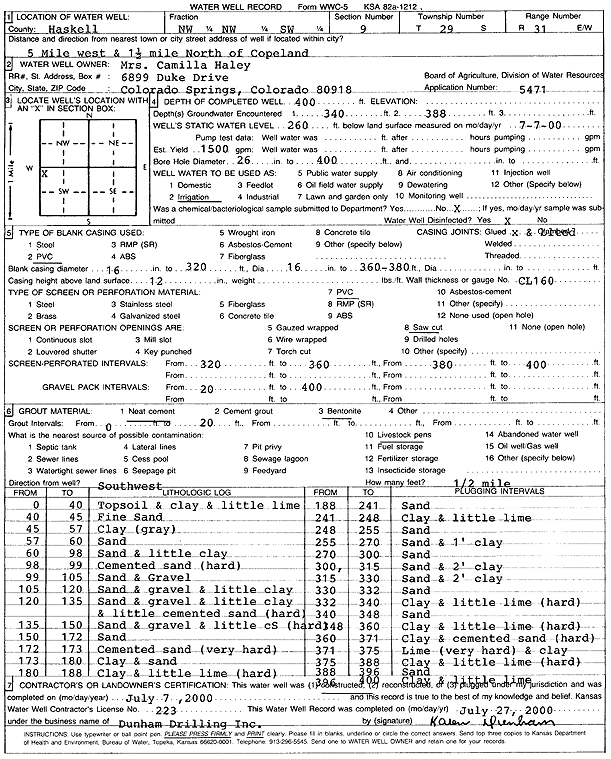
KGS Home Page Water Well Data base Specific Water Well Detail
Water Resources

Well T29S, R31W, Sec. 9, NW NW SW, Action: Constructed

Location Info
Owner: Haley, Camilla Status: Constructed
Location: T29S, R31W, Sec. 9, NW NW SW County: Haskell
Directions: from Copeland: 5 mi W, 1.5 mi N
Latitude: 37.5395293 Longitude: -100.7237989 Datum NAD 27
Latitude: 37.5395538 Longitude: -100.7242353 Datum NAD 83
Longitude and latitude calculated by Survey from township-range-section-quarter calls. Only good to within the quarter call accuracy.
View well on interactive map
General Info
Well Depth: 400 ft. Elevation: ft.
Static Water Level: 260 ft. Est. Yield: 1500 gpm.
Comp. Date: 07-Jul-2000 Well Use: Irrigation
DWR Applic. #: 5471 Other ID:
Links
View info from Wizard Water Level Data base...
View info from WIMAS Water Right Data base...
Driller Info
Driller: Donald R. Dunham Drilling, Inc. License #: 223
Scanned Form
View form(s) on screen Download scan(s)
The download files contain one or more TIFF images compressed into a ZIP archive. Your browser may be already set up to decompress these files. The TIFFs are 300 dpi archival-quality scans of the WWC5 forms and can be viewed by software like Adobe PhotoShop.
Chemical Sample Submitted?:
Water Well disinfected?:
Casing Info
Casing Type: PVC
Casing Joints:
Diam: 16 in. to 320 ft
Diam: 16 in. to 360 ft
Diam: 16 in. to 380 ft
Casing height above land surface: in
Casing Weight: lbs/ft
Wall thickness or gauge no.:
Screen and Perforation Info
Screen Type: PVC Screen Openings:
Screen-perforated intervals From: 320 ft to 360 ft
From: 380 ft to 400 ft
Gravel pack intervals From: ft to ft
Grout Info
Grout used: From: to ft
Source of Possible Contamination
Source:
Direction from well: Distance: ft
Lithologic Log
(Log data entered by KGS.)
From: 0 ft. to 40 ft. topsoil and clay and little lime
From: 40 ft. to 45 ft. fine sand
From: 45 ft. to 57 ft. clay (gray)
From: 57 ft. to 60 ft. sand
From: 60 ft. to 98 ft. sand and little clay
From: 98 ft. to 99 ft. cemented sand (hard)
From: 99 ft. to 105 ft. sand and gravel
From: 105 ft. to 120 ft. sand and gravel and little clay
From: 120 ft. to 135 ft. sand and gravel and little clay and little cemented sand (hard)
From: 135 ft. to 150 ft. sand and gravel and little cemented sand (hard)
From: 150 ft. to 172 ft. sand
From: 172 ft. to 173 ft. cemented sand (very hard)
From: 173 ft. to 180 ft. clay and sand
From: 180 ft. to 188 ft. clay and little lime (hard)
From: 188 ft. to 241 ft. sand
From: 241 ft. to 248 ft. clay and little lime
From: 248 ft. to 255 ft. sand
From: 255 ft. to 270 ft. sand and 1-foot clay
From: 270 ft. to 300 ft. sand
From: 300 ft. to 315 ft. sand and 2 feet clay
From: 315 ft. to 330 ft. sand and 2 feet clay
From: 330 ft. to 332 ft. sand
From: 332 ft. to 340 ft. clay and little lime (hard)
From: 340 ft. to 348 ft. sand
From: 348 ft. to 360 ft. clay and little lime (hard)
From: 360 ft. to 371 ft. clay and cemented sand (hard)
From: 371 ft. to 375 ft. lime (very hard) and clay
From: 375 ft. to 388 ft. clay and little lime (hard)
From: 388 ft. to 396 ft. sand
From: 396 ft. to 400 ft. clay and little lime

Kansas Geological Survey
Comments to kgs-webadmin@ku.edu
URL=http://www.kgs.ku.edu/Magellan/WaterWell/index.html
Display Programs Updated January 2, 2025
Data added continuously.