|
|
|
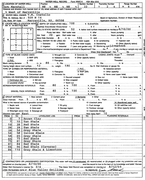
Specific Water Well Detail |
|
|
| Location Info | |||
| Owner: Costello, V.E. | Status: Constructed | ||
| Location: T2S, R6E, Sec. 33, NE NE NE | County: Marshall | ||
| Directions: From Marysville, 5 mi W | |||
| Latitude: 39.8411783 | Longitude: -96.7510708 | Datum NAD 27 | |
| Latitude: 39.8411808 | Longitude: -96.751371 | Datum NAD 83 | |
| Longitude and latitude calculated by Survey from township-range-section-quarter calls. Only good to within the quarter call accuracy. | |||
| View well on interactive map | |||
| General Info | ||
| Well Depth: 100 ft. | Elevation: ft. | |
| Static Water Level: 52 ft. | Est. Yield: 20 gpm. | |
| Comp. Date: 10-Aug-2000 | Well Use: Domestic, Livestock | |
| DWR Applic. #: | Other ID: | |
| Driller Info | ||
| Driller: Blue Valley Drilling | License #: 518 | |
| Scanned Form | View scan |
|
Chemical Sample Submitted?:
Water Well disinfected?: | ||
| Casing Info | ||
| Casing Type:
Casing Joints: |
Diam: in. to ft | |
| Casing height above land surface: in
Casing Weight: lbs/ft Wall thickness or gauge no.: | ||
| Screen and Perforation Info | ||
| Screen Type: | Screen Openings: | |
| Screen-perforated intervals | From: ft to ft | |
| Gravel pack intervals | From: ft to ft | |
| Grout Info | ||
| Grout used: | From: to ft | |
| Source of Possible Contamination | ||
| Source: | ||
| Direction from well: | Distance: ft | |
| Lithologic Log
(Log data entered by KGS.) | ||
| From: 0 ft. to 7 ft. | Clay, brown | |
| From: 7 ft. to 10 ft. | Shale, tan | |
| From: 10 ft. to 28 ft. | Shale, red | |
| From: 28 ft. to 39 ft. | Shale, tan | |
| From: 39 ft. to 54 ft. | Shale, gray | |
| From: 54 ft. to 58 ft. | Shale, yellow | |
| From: 58 ft. to 65 ft. | Shale, gray | |
| From: 65 ft. to 75 ft. | Shale, red | |
| From: 75 ft. to 81 ft. | Shale, gray | |
| From: 81 ft. to 84 ft. | Shale, red | |
| From: 84 ft. to 96 ft. | Shale, red (caverns) | |
| From: 96 ft. to 110 ft. | Gray shale and limestone | |