|
|
|
Specific Water Well Detail |
|
|
| Location Info | |||
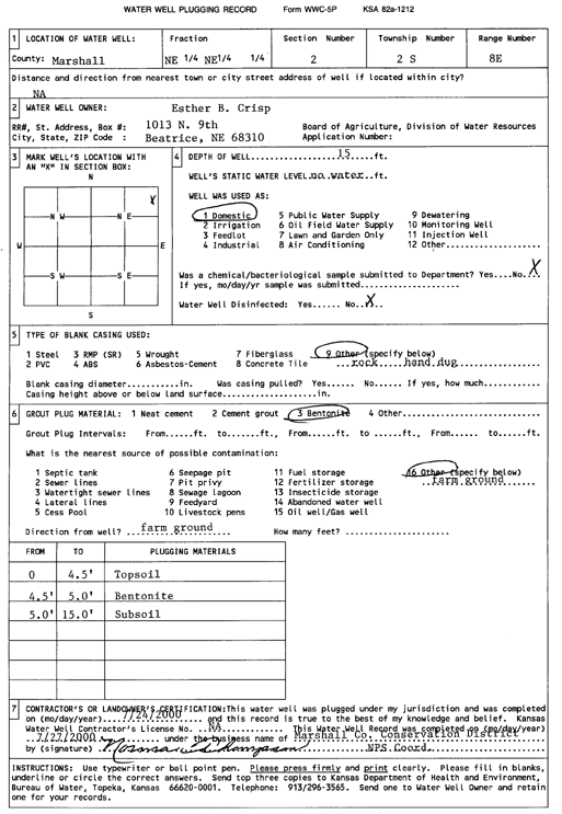
| Owner: Crisp, Esther B. | Status: Plugged | ||
| Location: T2S, R8E, Sec. 2, NE NE | County: Marshall | ||
| Directions: | |||
| Latitude: 39.9122008 | Longitude: -96.4845267 | Datum NAD 27 | |
| Latitude: 39.9122022 | Longitude: -96.4848217 | Datum NAD 83 | |
| Longitude and latitude calculated by Survey from township-range-section-quarter calls. Only good to within the quarter call accuracy. | |||
| View well on interactive map | |||
| General Info | ||
| Well Depth: 15 ft. | Elevation: ft. | |
| Static Water Level: ft. | Est. Yield: gpm. | |
| Comp. Date: 24-Jul-2000 | Well Use: Domestic | |
| DWR Applic. #: | Other ID: | |
| Links | |
| View info from Wizard Water Level Data base... | |
| No WIMAS information available. | |
| Driller Info | ||
| Driller: Norma Thompson | License #: | |
| Scanned Form | View scan |
| Casing Info | ||
|
Casing Type:
Diam: in. Casing height above land surface: in | ||
| Grout Info | ||
| Grout used: | From: to ft | |
| Source of Possible Contamination | ||
| Source: | ||
| Direction from well: | Distance: ft | |