|
|
|
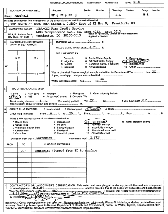
Specific Water Well Detail |
|
|
| Location Info | |||
| Owner: U.S. Dept. of Agriculture | Status: Plugged | ||
| Location: T4S, R9E, Sec. 9, SE NE SE | County: Marshall | ||
| Directions: 1380' N of E 10th St, 2500' E of KS Hwy 9, Frankfort | |||
| Latitude: 39.7158238 | Longitude: -96.4084928 | Datum NAD 27 | |
| Latitude: 39.7158231 | Longitude: -96.4087818 | Datum NAD 83 | |
| Longitude and latitude calculated by Survey from township-range-section-quarter calls. Only good to within the quarter call accuracy. | |||
| View well on interactive map | |||
| General Info | ||
| Well Depth: 20 ft. | Elevation: ft. | |
| Static Water Level: 4.23 ft. | Est. Yield: gpm. | |
| Comp. Date: 01-Aug-2000 | Well Use: Monitoring well/observation/piezometer | |
| DWR Applic. #: | Other ID: SB 18 | |
| Driller Info | ||
| Driller: Delta Environmental Services | License #: 680 | |
| Scanned Form | View scan |
| Casing Info | ||
|
Casing Type:
Diam: in. Casing height above land surface: in | ||
| Grout Info | ||
| Grout used: | From: to ft | |
| Source of Possible Contamination | ||
| Source: | ||
| Direction from well: | Distance: ft | |