|
|
|
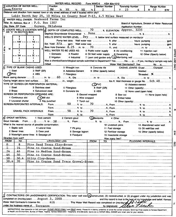
Specific Water Well Detail |
|
|
| Location Info | |||
| Owner: Seaboard Farms Inc. | Status: Constructed | ||
| Location: T23S, R37W, Sec. 2, NW NE NE | County: Kearny | ||
| Directions: from Lakin: 10 mi N on Hwy 25 to county rd P-13, 4.5 mi W | |||
| Latitude: 38.0891037 | Longitude: -101.3433614 | Datum NAD 27 | |
| Latitude: 38.0891227 | Longitude: -101.3438066 | Datum NAD 83 | |
| Longitude and latitude calculated by Survey from township-range-section-quarter calls. Only good to within the quarter call accuracy. | |||
| View well on interactive map | |||
| General Info | ||
| Well Depth: 70 ft. | Elevation: 3235 ft. | |
| Static Water Level: ft. | Est. Yield: gpm. | |
| Comp. Date: 03-Aug-2000 | Well Use: Monitoring well/observation/piezometer | |
| DWR Applic. #: | Other ID: | |
| Driller Info | ||
| Driller: Terracon, Inc. | License #: 416 | |
| Scanned Form | View scan |
|
Chemical Sample Submitted?:
Water Well disinfected?: | ||
| Casing Info | ||
| Casing Type:
Casing Joints: |
Diam: in. to ft | |
| Casing height above land surface: in
Casing Weight: lbs/ft Wall thickness or gauge no.: | ||
| Screen and Perforation Info | ||
| Screen Type: | Screen Openings: | |
| Screen-perforated intervals | From: ft to ft | |
| Gravel pack intervals | From: ft to ft | |
| Grout Info | ||
| Grout used: | From: to ft | |
| Source of Possible Contamination | ||
| Source: | ||
| Direction from well: | Distance: ft | |
| Lithologic Log
(Log data entered by KGS.) | ||
| From: 0 ft. to 8 ft. | fine sand trace clay - brown | |
| From: 8 ft. to 24 ft. | fine to coarse sand - brown | |
| From: 24 ft. to 46 ft. | fine to medium sand - brown | |
| From: 46 ft. to 50 ft. | fine to coarse sand - brown | |
| From: 50 ft. to 50.4 ft. | silty clay - brown | |
| From: 50.4 ft. to 70 ft. | fine to coarse sand trace gravel - brown | |