|
|
|
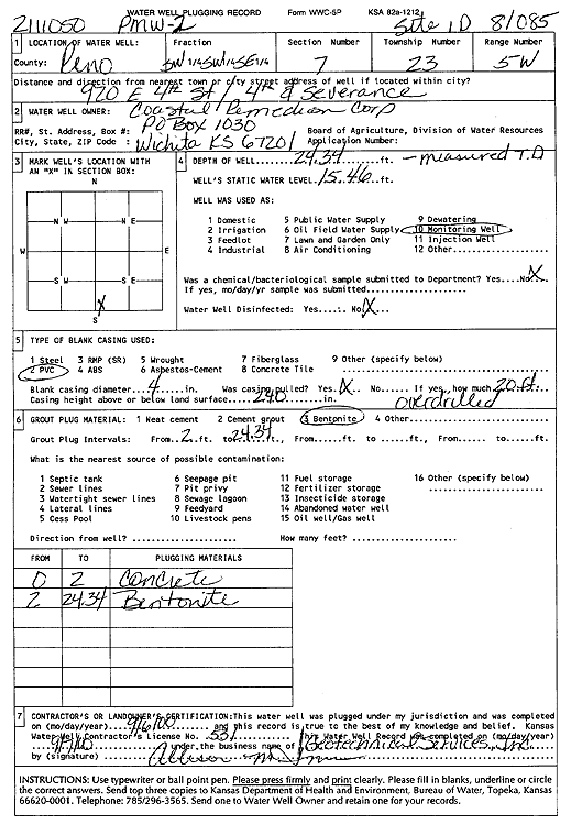
Specific Water Well Detail |
|
|
| Location Info | |||
| Owner: Coastal Remediation Corp. | Status: Plugged | ||
| Location: T23S, R5W, Sec. 7, SW SW SE | County: Reno | ||
| Directions: 920 E 4th St, 4th and Severance | |||
| Latitude: 38.0584346 | Longitude: -97.9115122 | Datum NAD 27 | |
| Latitude: 38.0584459 | Longitude: -97.9118417 | Datum NAD 83 | |
| Longitude and latitude calculated by Survey from township-range-section-quarter calls. Only good to within the quarter call accuracy. | |||
| View well on interactive map | |||
| General Info | ||
| Well Depth: 24.34 ft. | Elevation: ft. | |
| Static Water Level: 15.46 ft. | Est. Yield: gpm. | |
| Comp. Date: 06-Sep-2000 | Well Use: Monitoring well/observation/piezometer | |
| DWR Applic. #: 2111050 | Other ID: PMW 2 | |
| Driller Info | ||
| Driller: Geotechnical Services, Inc. | License #: 531 | |
| Scanned Form | View scan |
| Casing Info | ||
|
Casing Type:
Diam: in. Casing height above land surface: in | ||
| Grout Info | ||
| Grout used: | From: to ft | |
| Source of Possible Contamination | ||
| Source: | ||
| Direction from well: | Distance: ft | |