|
|
|
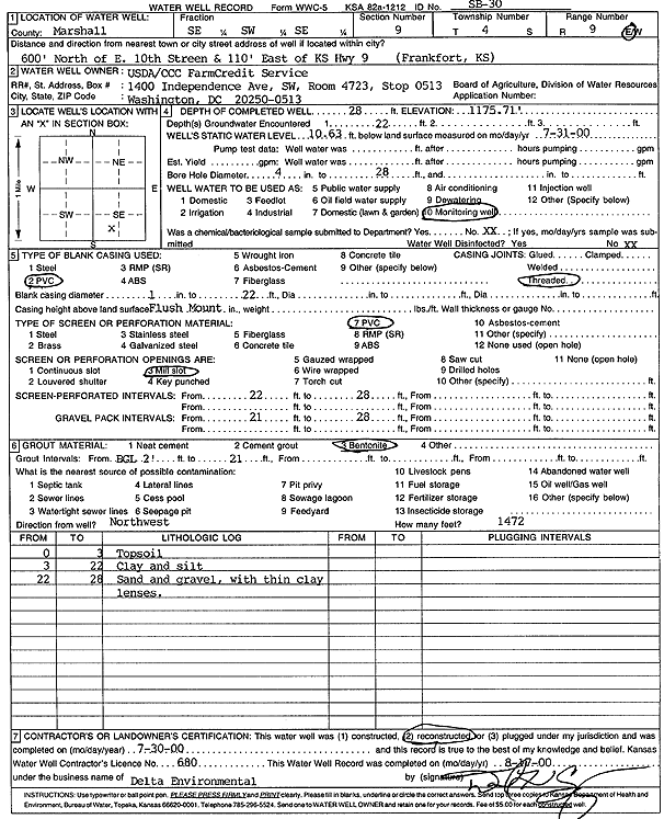
Specific Water Well Detail |
|
|
| Location Info | |||
| Owner: U.S. Dept. of Agriculture | Status: Reconstructed | ||
| Location: T4S, R9E, Sec. 9, SE SW SE | County: Marshall | ||
| Directions: in Frankfort: 600' N of E 10th St, 110' E of Hwy 9 | |||
| Latitude: 39.7121388 | Longitude: -96.4131888 | Datum NAD 27 | |
| Latitude: 39.7121381 | Longitude: -96.4134778 | Datum NAD 83 | |
| Longitude and latitude calculated by Survey from township-range-section-quarter calls. Only good to within the quarter call accuracy. | |||
| View well on interactive map | |||
| General Info | ||
| Well Depth: 28 ft. | Elevation: 1175.71 ft. | |
| Static Water Level: 10.63 ft. | Est. Yield: gpm. | |
| Comp. Date: 30-Jul-2000 | Well Use: Monitoring well/observation/piezometer | |
| DWR Applic. #: | Other ID: SB 30 | |
| Driller Info | ||
| Driller: Delta Environmental | License #: 680 | |
| Scanned Form | View scan |
|
Chemical Sample Submitted?:
Water Well disinfected?: | ||
| Casing Info | ||
| Casing Type:
Casing Joints: |
Diam: in. to ft | |
| Casing height above land surface: in
Casing Weight: lbs/ft Wall thickness or gauge no.: | ||
| Screen and Perforation Info | ||
| Screen Type: | Screen Openings: | |
| Screen-perforated intervals | From: ft to ft | |
| Gravel pack intervals | From: ft to ft | |
| Grout Info | ||
| Grout used: | From: to ft | |
| Source of Possible Contamination | ||
| Source: | ||
| Direction from well: | Distance: ft | |