|
|
|
Specific Water Well Detail |
|
|
| Location Info | |||
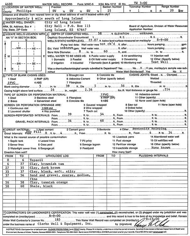
| Owner: City of Long Island | Status: Constructed | ||
| Location: T1S, R20W, Sec. 25, SW SW SW | County: Phillips | ||
| Directions: from Long Island: .5 mi S | |||
| Latitude: 39.9305042 | Longitude: -99.5323284 | Datum NAD 27 | |
| Latitude: 39.9305134 | Longitude: -99.5327117 | Datum NAD 83 | |
| Longitude and latitude calculated by Survey from township-range-section-quarter calls. Only good to within the quarter call accuracy. | |||
| View well on interactive map | |||
| General Info | ||
| Well Depth: 58 ft. | Elevation: ft. | |
| Static Water Level: 22.87 ft. | Est. Yield: gpm. | |
| Comp. Date: 09-Aug-2000 | Well Use: Test hole/well | |
| DWR Applic. #: | Other ID: | |
| Driller Info | ||
| Driller: Clarke Well and Equipment, Inc. | License #: 185 | |
| Scanned Form | View scan |
|
Chemical Sample Submitted?:
Water Well disinfected?: | ||
| Casing Info | ||
| Casing Type:
Casing Joints: |
Diam: in. to ft | |
| Casing height above land surface: in
Casing Weight: lbs/ft Wall thickness or gauge no.: | ||
| Screen and Perforation Info | ||
| Screen Type: | Screen Openings: | |
| Screen-perforated intervals | From: ft to ft | |
| Gravel pack intervals | From: ft to ft | |
| Grout Info | ||
| Grout used: | From: to ft | |
| Source of Possible Contamination | ||
| Source: | ||
| Direction from well: | Distance: ft | |
| Lithologic Log
(Log data entered by KGS.) | ||
| From: 0 ft. to 6 ft. | topsoil | |
| From: 6 ft. to 27 ft. | clay, brownish, tan | |
| From: 27 ft. to 35 ft. | clay, dark brown | |
| From: 35 ft. to 37 ft. | clay, black, soft, silty | |
| From: 37 ft. to 56 ft. | sand and gravel, coarse, medium, fine | |
| From: 56 ft. to 58 ft. | clay, tannish orange | |
| From: 58 ft. to 60 ft. | shale, black | |