|
|
|
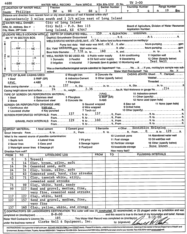
Specific Water Well Detail |
|
|
| Location Info | |||
| Owner: City of Long Island | Status: Constructed | ||
| Location: T2S, R19W, Sec. 7, NW NE SE | County: Phillips | ||
| Directions: from Long Island: 3 mi S, 1.75 mi E | |||
| Latitude: 39.8927079 | Longitude: -99.4997984 | Datum NAD 27 | |
| Latitude: 39.8927173 | Longitude: -99.5001801 | Datum NAD 83 | |
| Longitude and latitude calculated by Survey from township-range-section-quarter calls. Only good to within the quarter call accuracy. | |||
| View well on interactive map | |||
| General Info | ||
| Well Depth: 159 ft. | Elevation: ft. | |
| Static Water Level: ft. | Est. Yield: gpm. | |
| Comp. Date: 08-Aug-2000 | Well Use: Test hole/well | |
| DWR Applic. #: | Other ID: TW 2-00 | |
| Driller Info | ||
| Driller: Clarke Well and Equipment, Inc. | License #: 185 | |
| Scanned Form | View scan |
|
Chemical Sample Submitted?:
Water Well disinfected?: | ||
| Casing Info | ||
| Casing Type:
Casing Joints: |
Diam: in. to ft | |
| Casing height above land surface: in
Casing Weight: lbs/ft Wall thickness or gauge no.: | ||
| Screen and Perforation Info | ||
| Screen Type: | Screen Openings: | |
| Screen-perforated intervals | From: ft to ft | |
| Gravel pack intervals | From: ft to ft | |
| Grout Info | ||
| Grout used: | From: to ft | |
| Source of Possible Contamination | ||
| Source: | ||
| Direction from well: | Distance: ft | |
| Lithologic Log
(Log data entered by KGS.) | ||
| From: 0 ft. to 5 ft. | topsoil | |
| From: 5 ft. to 14 ft. | clay, brown, silty, soft | |
| From: 14 ft. to 24 ft. | cemented sand, soft | |
| From: 24 ft. to 31 ft. | clay, brown, silty, soft | |
| From: 31 ft. to 63 ft. | cemented sand, hard, clay streaks | |
| From: 63 ft. to 71 ft. | clay, tannish white, silty, cemented sand streaks | |
| From: 71 ft. to 99 ft. | clay, white, hard, sandy | |
| From: 99 ft. to 117 ft. | sand and gravel, medium, fine, very fine, cemented sand streaks | |
| From: 117 ft. to 127 ft. | clay, white hard | |
| From: 127 ft. to 157 ft. | sand and gravel, medium, fine, very fine | |
| From: 157 ft. to 160 ft. | clay, yellow, white, and orange | |