|
|
|
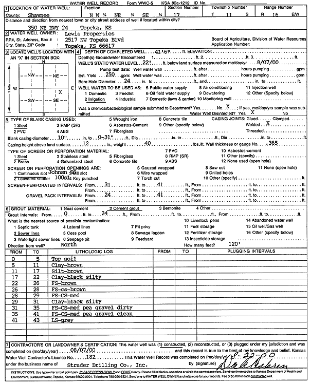
Specific Water Well Detail |
|
|
| Location Info | |||
| Owner: Lewis Properties | Status: Constructed | ||
| Location: T11S, R16E, Sec. 17, NW NE SE | County: Shawnee | ||
| Directions: 350 NE Hwy 24, Topeka | |||
| Latitude: 39.0941605 | Longitude: -95.6536281 | Datum NAD 27 | |
| Latitude: 39.0941601 | Longitude: -95.6538866 | Datum NAD 83 | |
| Longitude and latitude calculated by Survey from township-range-section-quarter calls. Only good to within the quarter call accuracy. | |||
| View well on interactive map | |||
| General Info | ||
| Well Depth: 41.6 ft. | Elevation: ft. | |
| Static Water Level: 22 ft. | Est. Yield: 250 gpm. | |
| Comp. Date: 07-Aug-2000 | Well Use: Irrigation | |
| DWR Applic. #: | Other ID: | |
| Links | |
| No Wizard information available. | |
| View info from WIMAS Water Right Data base... | |
| Driller Info | ||
| Driller: Strader Drilling Co., Inc. | License #: 182 | |
| Scanned Form | View scan |
|
Chemical Sample Submitted?:
Water Well disinfected?: | ||
| Casing Info | ||
| Casing Type:
Casing Joints: |
Diam: in. to ft | |
| Casing height above land surface: in
Casing Weight: lbs/ft Wall thickness or gauge no.: | ||
| Screen and Perforation Info | ||
| Screen Type: | Screen Openings: | |
| Screen-perforated intervals | From: ft to ft | |
| Gravel pack intervals | From: ft to ft | |
| Grout Info | ||
| Grout used: | From: to ft | |
| Source of Possible Contamination | ||
| Source: | ||
| Direction from well: | Distance: ft | |
| Lithologic Log
(Log data entered by KGS.) | ||
| From: 0 ft. to 5 ft. | top soil | |
| From: 5 ft. to 11 ft. | clay, brown | |
| From: 11 ft. to 17 ft. | silt, brown | |
| From: 17 ft. to 22 ft. | clay, black, silty | |
| From: 22 ft. to 26 ft. | fine sand, brown | |
| From: 26 ft. to 28 ft. | fine sand, coarse sand, brown | |
| From: 28 ft. to 29 ft. | fine sand, coarse sand, medium | |
| From: 29 ft. to 31 ft. | clay, black, silty | |
| From: 31 ft. to 35 ft. | fine sand, coarse sand, medium pea gravel, dirty | |
| From: 35 ft. to 41 ft. | fine sand, coarse sand, medium pea gravel, clean | |
| From: 41 ft. to 43 ft. | limestone, gray | |