|
|
|
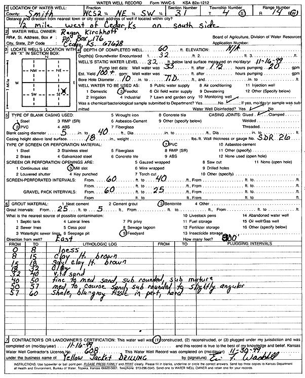
Specific Water Well Detail |
|
|
| Location Info | |||
| Owner: Kirchhoff, Regan | Status: Constructed | ||
| Location: T4S, R14W, Sec. 31, NC S2 NE SW | County: Smith | ||
| Directions: from Cedar, 0.5 mi W on S side | |||
| Latitude: 39.6593453 | Longitude: -98.9465991 | Datum NAD 27 | |
| Latitude: 39.6593564 | Longitude: -98.9469584 | Datum NAD 83 | |
| Longitude and latitude calculated by Survey from township-range-section-quarter calls. Only good to within the quarter call accuracy. | |||
| View well on interactive map | |||
| General Info | ||
| Well Depth: 60 ft. | Elevation: ft. | |
| Static Water Level: 32 ft. | Est. Yield: 100 gpm. | |
| Comp. Date: 16-Nov-1999 | Well Use: Domestic, Livestock | |
| DWR Applic. #: | Other ID: | |
| Driller Info | ||
| Driller: Yellow Jacket Drilling | License #: 608 | |
| Scanned Form | View scan |
|
Chemical Sample Submitted?:
Water Well disinfected?: | ||
| Casing Info | ||
| Casing Type:
Casing Joints: |
Diam: in. to ft | |
| Casing height above land surface: in
Casing Weight: lbs/ft Wall thickness or gauge no.: | ||
| Screen and Perforation Info | ||
| Screen Type: | Screen Openings: | |
| Screen-perforated intervals | From: ft to ft | |
| Gravel pack intervals | From: ft to ft | |
| Grout Info | ||
| Grout used: | From: to ft | |
| Source of Possible Contamination | ||
| Source: | ||
| Direction from well: | Distance: ft | |
| Lithologic Log
(Log data entered by KGS.) | ||
| From: 0 ft. to 8 ft. | loess | |
| From: 8 ft. to 15 ft. | clay, light brown | |
| From: 15 ft. to 18 ft. | sandy clay, light brown | |
| From: 18 ft. to 32 ft. | clay | |
| From: 32 ft. to 40 ft. | very fine sand | |
| From: 40 ft. to 50 ft. | fine to medium sand, sub rounded, sub mature | |
| From: 50 ft. to 57 ft. | medium to coarse sand, sub rounded to slightly angular | |
| From: 57 ft. to 60 ft. | shale, blue-gray, fissile and part, hard | |