|
|
|
Specific Water Well Detail |
|
|
| Location Info | |||
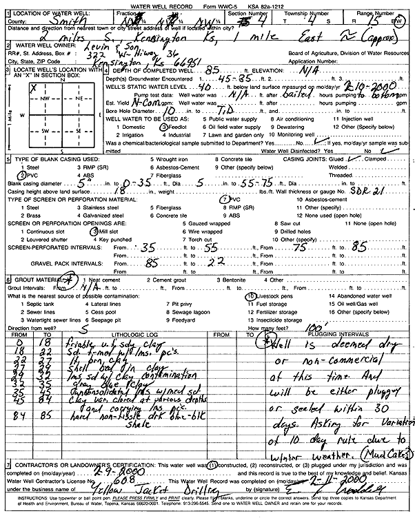
| Owner: Levin and Son | Status: Constructed | ||
| Location: T4S, R15W, Sec. 4, NW | County: Smith | ||
| Directions: from Kensington, 2 mi S, 1 mi E | |||
| Latitude: 39.738305 | Longitude: -99.0239 | Datum NAD 27 | |
| Latitude: 39.7383164 | Longitude: -99.0242616 | Datum NAD 83 | |
| Longitude and latitude calculated by Survey from township-range-section-quarter calls. Only good to within the quarter call accuracy. | |||
| View well on interactive map | |||
| General Info | ||
| Well Depth: 85 ft. | Elevation: ft. | |
| Static Water Level: 40 ft. | Est. Yield: gpm. | |
| Comp. Date: 09-Feb-2000 | Well Use: Domestic, Livestock | |
| DWR Applic. #: | Other ID: | |
| Driller Info | ||
| Driller: Yellow Jacket Drilling | License #: 608 | |
| Scanned Form | View scan |
|
Chemical Sample Submitted?:
Water Well disinfected?: | ||
| Casing Info | ||
| Casing Type:
Casing Joints: |
Diam: in. to ft | |
| Casing height above land surface: in
Casing Weight: lbs/ft Wall thickness or gauge no.: | ||
| Screen and Perforation Info | ||
| Screen Type: | Screen Openings: | |
| Screen-perforated intervals | From: ft to ft | |
| Gravel pack intervals | From: ft to ft | |
| Grout Info | ||
| Grout used: | From: to ft | |
| Source of Possible Contamination | ||
| Source: | ||
| Direction from well: | Distance: ft | |
| Lithologic Log
(Log data entered by KGS.) | ||
| From: 0 ft. to 18 ft. | friable very fine sand clay | |
| From: 18 ft. to 22 ft. | sand, fine-medium with limestone pieces | |
| From: 22 ft. to 27 ft. | light brown clay | |
| From: 27 ft. to 29 ft. | shell bed in clay | |
| From: 29 ft. to 32 ft. | limestone sand with clay contamination | |
| From: 32 ft. to 35 ft. | gray blue clay | |
| From: 35 ft. to 45 ft. | unconsolidated limestone with medium sand | |
| From: 45 ft. to 84 ft. | clay, variable color at various depths and carrying limestone pieces | |
| From: 84 ft. to 85 ft. | hard non-fissile dark blue-black shale | |