|
|
|
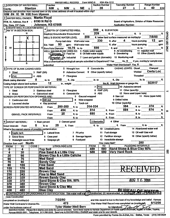
Specific Water Well Detail |
|
|
| Location Info | |||
| Owner: Floyd, Martie | Status: Constructed | ||
| Location: T27S, R40W, Sec. 35, NW NW NE | County: Stanton | ||
| Directions: from Ulysses: 18 mi W, 5 mi N, 1 mi E, 1 mi N, .5 mi E | |||
| Latitude: 37.6633803 | Longitude: -101.6609079 | Datum NAD 27 | |
| Latitude: 37.663396 | Longitude: -101.6613571 | Datum NAD 83 | |
| Longitude and latitude calculated by Survey from township-range-section-quarter calls. Only good to within the quarter call accuracy. | |||
| View well on interactive map | |||
| General Info | ||
| Well Depth: 590 ft. | Elevation: ft. | |
| Static Water Level: 209 ft. | Est. Yield: 50 gpm. | |
| Comp. Date: 22-Jul-2000 | Well Use: Irrigation | |
| DWR Applic. #: | Other ID: | |
| Driller Info | ||
| Driller: Destal Tyler Water Well Service | License #: 473 | |
| Scanned Form | View scan |
|
Chemical Sample Submitted?:
Water Well disinfected?: | ||
| Casing Info | ||
| Casing Type:
Casing Joints: |
Diam: in. to ft | |
| Casing height above land surface: in
Casing Weight: lbs/ft Wall thickness or gauge no.: | ||
| Screen and Perforation Info | ||
| Screen Type: | Screen Openings: | |
| Screen-perforated intervals | From: ft to ft | |
| Gravel pack intervals | From: ft to ft | |
| Grout Info | ||
| Grout used: | From: to ft | |
| Source of Possible Contamination | ||
| Source: | ||
| Direction from well: | Distance: ft | |
| Lithologic Log
(Log data entered by KGS.) | ||
| From: 0 ft. to 4 ft. | top soil | |
| From: 4 ft. to 20 ft. | fine sand and a little clay | |
| From: 20 ft. to 66 ft. | brown clay and a little caliche | |
| From: 66 ft. to 76 ft. | medium sand | |
| From: 76 ft. to 80 ft. | sandy clay | |
| From: 80 ft. to 155 ft. | fine sand | |
| From: 155 ft. to 170 ft. | medium sand | |
| From: 170 ft. to 235 ft. | brown clay | |
| From: 235 ft. to 243 ft. | fine to medium sand | |
| From: 243 ft. to 320 ft. | brown sandy clay | |
| From: 320 ft. to 370 ft. | sandstone and clay stk 50% | |
| From: 370 ft. to 380 ft. | brown clay | |
| From: 380 ft. to 400 ft. | sandstone and clay mix | |
| From: 400 ft. to 480 ft. | blue clay | |
| From: 480 ft. to 580 ft. | sandstone and blue clay 50% | |
| From: 580 ft. to 590 ft. | very hard rock | |