|
|
|
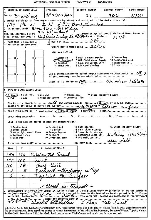
Specific Water Well Detail |
|
|
| Location Info | |||
| Owner: Lottridge, Etta Jane | Status: Plugged | ||
| Location: T30S, R39W, Sec. 21, SE SE NW | County: Stanton | ||
| Directions: from Big Bow, 10 mi S, 1.5 mi W, and 0.5 mi N | |||
| Latitude: 37.4257173 | Longitude: -101.5904087 | Datum NAD 27 | |
| Latitude: 37.4257385 | Longitude: -101.5908528 | Datum NAD 83 | |
| Longitude and latitude calculated by Survey from township-range-section-quarter calls. Only good to within the quarter call accuracy. | |||
| View well on interactive map | |||
| General Info | ||
| Well Depth: 350 ft. | Elevation: ft. | |
| Static Water Level: 200 ft. | Est. Yield: gpm. | |
| Comp. Date: 01-May-2000 | Well Use: Irrigation | |
| DWR Applic. #: 13118 | Other ID: | |
| Links | |
| View info from Wizard Water Level Data base... | |
| View info from WIMAS Water Right Data base... | |
| Driller Info | ||
| Driller: well owner | License #: | |
| Scanned Form | View scan |
| Casing Info | ||
|
Casing Type:
Diam: in. Casing height above land surface: in | ||
| Grout Info | ||
| Grout used: | From: to ft | |
| Source of Possible Contamination | ||
| Source: | ||
| Direction from well: | Distance: ft | |