|
|
|
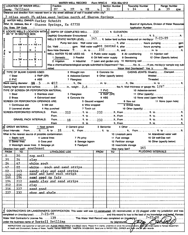
Specific Water Well Detail |
|
|
| Location Info | |||
| Owner: Schmidt, Harley | Status: Constructed | ||
| Location: T14S, R39W, Sec. 31, SW NE NE | County: Wallace | ||
| Directions: from Sharon Springs, 7 mi S, 2.5 mi E, and 0.5 mi N | |||
| Latitude: 38.7977551 | Longitude: -101.6896186 | Datum NAD 27 | |
| Latitude: 38.7977664 | Longitude: -101.6900662 | Datum NAD 83 | |
| Longitude and latitude calculated by Survey from township-range-section-quarter calls. Only good to within the quarter call accuracy. | |||
| View well on interactive map | |||
| General Info | ||
| Well Depth: 232 ft. | Elevation: ft. | |
| Static Water Level: 145 ft. | Est. Yield: gpm. | |
| Comp. Date: 23-Jul-1999 | Well Use: Domestic | |
| DWR Applic. #: | Other ID: | |
| Driller Info | ||
| Driller: Bartell Drilling & Machine Works | License #: 139 | |
| Scanned Form | View scan |
|
Chemical Sample Submitted?:
Water Well disinfected?: | ||
| Casing Info | ||
| Casing Type:
Casing Joints: |
Diam: in. to ft | |
| Casing height above land surface: in
Casing Weight: lbs/ft Wall thickness or gauge no.: | ||
| Screen and Perforation Info | ||
| Screen Type: | Screen Openings: | |
| Screen-perforated intervals | From: ft to ft | |
| Gravel pack intervals | From: ft to ft | |
| Grout Info | ||
| Grout used: | From: to ft | |
| Source of Possible Contamination | ||
| Source: | ||
| Direction from well: | Distance: ft | |
| Lithologic Log
(Log data entered by KGS.) | ||
| From: 0 ft. to 20 ft. | top soil | |
| From: 20 ft. to 24 ft. | clay | |
| From: 24 ft. to 47 ft. | white rock | |
| From: 47 ft. to 82 ft. | white rock and sand strips | |
| From: 82 ft. to 143 ft. | sandy clay and sand strips | |
| From: 143 ft. to 166 ft. | sand and sand rock strips | |
| From: 166 ft. to 194 ft. | sand good to fair | |
| From: 194 ft. to 212 ft. | sandy clay and sand strips | |
| From: 212 ft. to 216 ft. | clay | |
| From: 216 ft. to 227 ft. | sand good | |
| From: 227 ft. to 232 ft. | Ochre and shale | |