|
|
|
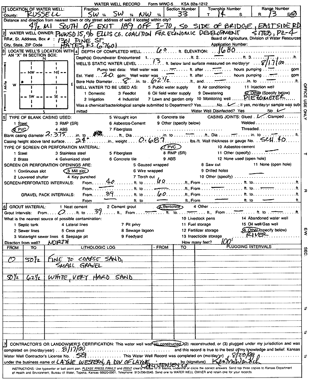
Specific Water Well Detail |
|
|
| Location Info | |||
| Owner: Public Wholesale Water Supply District 15 | Status: Constructed | ||
| Location: T14S, R13W, Sec. 33, SW SW NW | County: Russell | ||
| Directions: 4.5 mi S of exit 189 off I-70, S of bridge, E of road | |||
| Latitude: 38.7920735 | Longitude: -98.7793452 | Datum NAD 27 | |
| Latitude: 38.7920848 | Longitude: -98.7797039 | Datum NAD 83 | |
| Longitude and latitude calculated by Survey from township-range-section-quarter calls. Only good to within the quarter call accuracy. | |||
| View well on interactive map | |||
| General Info | ||
| Well Depth: 60 ft. | Elevation: 1680 ft. | |
| Static Water Level: 13 ft. | Est. Yield: 20 gpm. | |
| Comp. Date: 17-Aug-2000 | Well Use: Monitoring well/observation/piezometer | |
| DWR Applic. #: | Other ID: PZ 4 B | |
| Driller Info | ||
| Driller: Layne Western | License #: 581 | |
| Scanned Form | View scan |
|
Chemical Sample Submitted?:
Water Well disinfected?: | ||
| Casing Info | ||
| Casing Type:
Casing Joints: |
Diam: in. to ft | |
| Casing height above land surface: in
Casing Weight: lbs/ft Wall thickness or gauge no.: | ||
| Screen and Perforation Info | ||
| Screen Type: | Screen Openings: | |
| Screen-perforated intervals | From: ft to ft | |
| Gravel pack intervals | From: ft to ft | |
| Grout Info | ||
| Grout used: | From: to ft | |
| Source of Possible Contamination | ||
| Source: | ||
| Direction from well: | Distance: ft | |
| Lithologic Log
(Log data entered by KGS.) | ||
| From: 0 ft. to 50.5 ft. | fine to coarse sand, small gravel | |
| From: 50.5 ft. to 62.5 ft. | white very hard sand | |