|
|
|
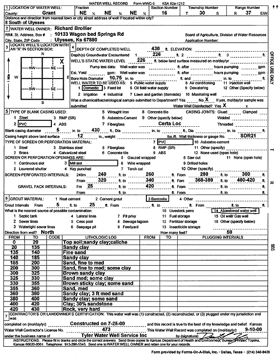
Specific Water Well Detail |
|
|
| Location Info | |||
| Owner: Brollier, Richard | Status: Constructed | ||
| Location: T30S, R37W, Sec. 16, NE NE NE | County: Grant | ||
| Directions: from Ulysses: 8 mi S | |||
| Latitude: 37.4449484 | Longitude: -101.3628267 | Datum NAD 27 | |
| Latitude: 37.444971 | Longitude: -101.3632705 | Datum NAD 83 | |
| Longitude and latitude calculated by Survey from township-range-section-quarter calls. Only good to within the quarter call accuracy. | |||
| View well on interactive map | |||
| General Info | ||
| Well Depth: 430 ft. | Elevation: ft. | |
| Static Water Level: 226 ft. | Est. Yield: gpm. | |
| Comp. Date: 25-Jul-2000 | Well Use: Domestic | |
| DWR Applic. #: | Other ID: | |
| Driller Info | ||
| Driller: Destal Tyler Water Well Service | License #: 473 | |
| Scanned Form | View scan |
|
Chemical Sample Submitted?:
Water Well disinfected?: | ||
| Casing Info | ||
| Casing Type:
Casing Joints: |
Diam: in. to ft | |
| Casing height above land surface: in
Casing Weight: lbs/ft Wall thickness or gauge no.: | ||
| Screen and Perforation Info | ||
| Screen Type: | Screen Openings: | |
| Screen-perforated intervals | From: ft to ft | |
| Gravel pack intervals | From: ft to ft | |
| Grout Info | ||
| Grout used: | From: to ft | |
| Source of Possible Contamination | ||
| Source: | ||
| Direction from well: | Distance: ft | |
| Lithologic Log
(Log data entered by KGS.) | ||
| From: 0 ft. to 20 ft. | Top soil; sandy clay; caliche | |
| From: 20 ft. to 135 ft. | Sandy clay | |
| From: 135 ft. to 140 ft. | Fine sand | |
| From: 140 ft. to 185 ft. | Sandy clay | |
| From: 185 ft. to 200 ft. | Sand, fine to med | |
| From: 200 ft. to 300 ft. | Sand, fine to med; some clay | |
| From: 300 ft. to 325 ft. | Brown sandy clay | |
| From: 325 ft. to 330 ft. | Sand med; some clay | |
| From: 330 ft. to 355 ft. | Brown sticky clay; some sand | |
| From: 355 ft. to 360 ft. | Sand, med | |
| From: 360 ft. to 380 ft. | Sandy clay; 3 ft medium sand | |
| From: 380 ft. to 400 ft. | Sandy clay; some sand | |
| From: 400 ft. to 420 ft. | Clay 30% sandstone | |
| From: 420 ft. to 430 ft. | Rock, very hard | |