|
|
|
Specific Water Well Detail |
|
|
| Location Info | |||
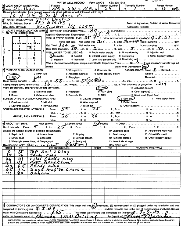
| Owner: Dennis, Jason | Status: Constructed | ||
| Location: T1S, R16W, Sec. 24, NE SW NE | County: Phillips | ||
| Directions: from Agra, 10 mi N, 2 mi E, and 3.75 mi N | |||
| Latitude: 39.9548128 | Longitude: -99.0726832 | Datum NAD 27 | |
| Latitude: 39.9548252 | Longitude: -99.0730462 | Datum NAD 83 | |
| Longitude and latitude calculated by Survey from township-range-section-quarter calls. Only good to within the quarter call accuracy. | |||
| View well on interactive map | |||
| General Info | ||
| Well Depth: 80 ft. | Elevation: ft. | |
| Static Water Level: 28.75 ft. | Est. Yield: 10 gpm. | |
| Comp. Date: 05-Sep-2000 | Well Use: Domestic | |
| DWR Applic. #: | Other ID: | |
| Driller Info | ||
| Driller: Leroy Maruhn Well Drilling, Inc. | License #: 165 | |
| Scanned Form | View scan |
|
Chemical Sample Submitted?:
Water Well disinfected?: | ||
| Casing Info | ||
| Casing Type:
Casing Joints: |
Diam: in. to ft | |
| Casing height above land surface: in
Casing Weight: lbs/ft Wall thickness or gauge no.: | ||
| Screen and Perforation Info | ||
| Screen Type: | Screen Openings: | |
| Screen-perforated intervals | From: ft to ft | |
| Gravel pack intervals | From: ft to ft | |
| Grout Info | ||
| Grout used: | From: to ft | |
| Source of Possible Contamination | ||
| Source: | ||
| Direction from well: | Distance: ft | |
| Lithologic Log
(Log data entered by KGS.) | ||
| From: 0 ft. to 15 ft. | topsoil and clay | |
| From: 15 ft. to 26 ft. | sandy clay | |
| From: 26 ft. to 41 ft. | extra sandy clay | |
| From: 41 ft. to 43 ft. | soft sandstone | |
| From: 43 ft. to 65 ft. | sandy clay | |
| From: 65 ft. to 72 ft. | sand medium to coarse | |
| From: 72 ft. to 80 ft. | ochre | |