|
|
|
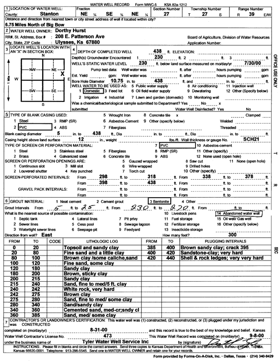
Specific Water Well Detail |
|
|
| Location Info | |||
| Owner: Hurst, Dorthy | Status: Constructed | ||
| Location: T27S, R39W, Sec. 27, NE SE NE | County: Stanton | ||
| Directions: from Big Bow: 6.75 mi N | |||
| Latitude: 37.6738925 | Longitude: -101.5635808 | Datum NAD 27 | |
| Latitude: 37.6739087 | Longitude: -101.5640294 | Datum NAD 83 | |
| Longitude and latitude calculated by Survey from township-range-section-quarter calls. Only good to within the quarter call accuracy. | |||
| View well on interactive map | |||
| General Info | ||
| Well Depth: 438 ft. | Elevation: ft. | |
| Static Water Level: 230 ft. | Est. Yield: gpm. | |
| Comp. Date: 31-Aug-2000 | Well Use: Domestic | |
| DWR Applic. #: | Other ID: | |
| Driller Info | ||
| Driller: Destal Tyler Water Well Service | License #: 473 | |
| Scanned Form | View scan |
|
Chemical Sample Submitted?:
Water Well disinfected?: | ||
| Casing Info | ||
| Casing Type:
Casing Joints: |
Diam: in. to ft | |
| Casing height above land surface: in
Casing Weight: lbs/ft Wall thickness or gauge no.: | ||
| Screen and Perforation Info | ||
| Screen Type: | Screen Openings: | |
| Screen-perforated intervals | From: ft to ft | |
| Gravel pack intervals | From: ft to ft | |
| Grout Info | ||
| Grout used: | From: to ft | |
| Source of Possible Contamination | ||
| Source: | ||
| Direction from well: | Distance: ft | |
| Lithologic Log
(Log data entered by KGS.) | ||
| From: 0 ft. to 20 ft. | topsoil and sandy clay | |
| From: 20 ft. to 80 ft. | fine sand and a little clay | |
| From: 80 ft. to 100 ft. | brown clay/some caliche, sand | |
| From: 100 ft. to 120 ft. | fine sand, some clay | |
| From: 120 ft. to 180 ft. | sandy clay | |
| From: 180 ft. to 200 ft. | brown, sticky clay | |
| From: 200 ft. to 215 ft. | sandy clay | |
| From: 215 ft. to 240 ft. | sand, fine to medium/5 ft clay | |
| From: 240 ft. to 242 ft. | white rock, very hard | |
| From: 242 ft. to 275 ft. | brown clay | |
| From: 275 ft. to 280 ft. | sand, fine to medium/some clay | |
| From: 280 ft. to 340 ft. | sand/sandy clay | |
| From: 340 ft. to 360 ft. | cemented sand, medium to coarse sandy clay | |
| From: 360 ft. to 385 ft. | sand, medium/some clay | |
| From: 385 ft. to 400 ft. | brown sandy clay; crack 395 | |
| From: 400 ft. to 420 ft. | sandstone - clay; very hard | |
| From: 420 ft. to 440 ft. | shell and rock ledges; very very hard | |