|
|
|
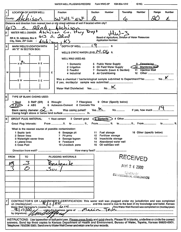
Specific Water Well Detail |
|
|
| Location Info | |||
| Owner: Atchison County Highway Dept. | Status: Plugged | ||
| Location: T6S, R20E, Sec. 2, SW NE NW | County: Atchison | ||
| Directions: 613 S 22nd, Atchison | |||
| Latitude: 39.5626936 | Longitude: -95.1552838 | Datum NAD 27 | |
| Latitude: 39.5626905 | Longitude: -95.1555313 | Datum NAD 83 | |
| Longitude and latitude calculated by Survey from township-range-section-quarter calls. Only good to within the quarter call accuracy. | |||
| View well on interactive map | |||
| General Info | ||
| Well Depth: 19 ft. | Elevation: ft. | |
| Static Water Level: 14.06 ft. | Est. Yield: gpm. | |
| Comp. Date: 01-Aug-2000 | Well Use: Monitoring well/observation/piezometer | |
| DWR Applic. #: | Other ID: MW 3 | |
| Driller Info | ||
| Driller: Maxim Technologies, Inc. | License #: 614 | |
| Scanned Form | View scan |
| Casing Info | ||
|
Casing Type:
Diam: in. Casing height above land surface: in | ||
| Grout Info | ||
| Grout used: | From: to ft | |
| Source of Possible Contamination | ||
| Source: | ||
| Direction from well: | Distance: ft | |