|
|
|
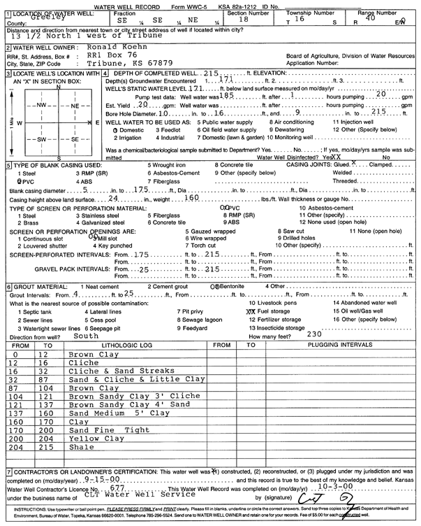
Specific Water Well Detail |
|
|
| Location Info | |||
| Owner: Koehn, Ronald | Status: Constructed | ||
| Location: T16S, R40W, Sec. 18, SE SE NE | County: Greeley | ||
| Directions: from Tribune, 13.5 mi N and 1 mi W | |||
| Latitude: 38.6627905 | Longitude: -101.7718866 | Datum NAD 27 | |
| Latitude: 38.6628037 | Longitude: -101.7723364 | Datum NAD 83 | |
| Longitude and latitude calculated by Survey from township-range-section-quarter calls. Only good to within the quarter call accuracy. | |||
| View well on interactive map | |||
| General Info | ||
| Well Depth: 215 ft. | Elevation: ft. | |
| Static Water Level: 171 ft. | Est. Yield: 20 gpm. | |
| Comp. Date: 15-Sep-2000 | Well Use: Domestic | |
| DWR Applic. #: | Other ID: | |
| Driller Info | ||
| Driller: CLT Inc. | License #: 677 | |
| Scanned Form | View scan |
|
Chemical Sample Submitted?:
Water Well disinfected?: | ||
| Casing Info | ||
| Casing Type:
Casing Joints: |
Diam: in. to ft | |
| Casing height above land surface: in
Casing Weight: lbs/ft Wall thickness or gauge no.: | ||
| Screen and Perforation Info | ||
| Screen Type: | Screen Openings: | |
| Screen-perforated intervals | From: ft to ft | |
| Gravel pack intervals | From: ft to ft | |
| Grout Info | ||
| Grout used: | From: to ft | |
| Source of Possible Contamination | ||
| Source: | ||
| Direction from well: | Distance: ft | |
| Lithologic Log
(Log data entered by KGS.) | ||
| From: 0 ft. to 12 ft. | Brown clay | |
| From: 12 ft. to 16 ft. | Caliche | |
| From: 16 ft. to 32 ft. | Caliche and sand streaks | |
| From: 32 ft. to 87 ft. | Sand and caliche and little clay | |
| From: 87 ft. to 104 ft. | Brown clay | |
| From: 104 ft. to 121 ft. | Brown sandy clay 3-foot caliche | |
| From: 121 ft. to 137 ft. | Brown sandy clay 4-foot sand | |
| From: 137 ft. to 160 ft. | Sand, medium, 5-foot clay | |
| From: 160 ft. to 170 ft. | Clay | |
| From: 170 ft. to 200 ft. | Sand, fine, tight | |
| From: 200 ft. to 204 ft. | Yellow clay | |
| From: 204 ft. to 215 ft. | Shale | |