|
|
|
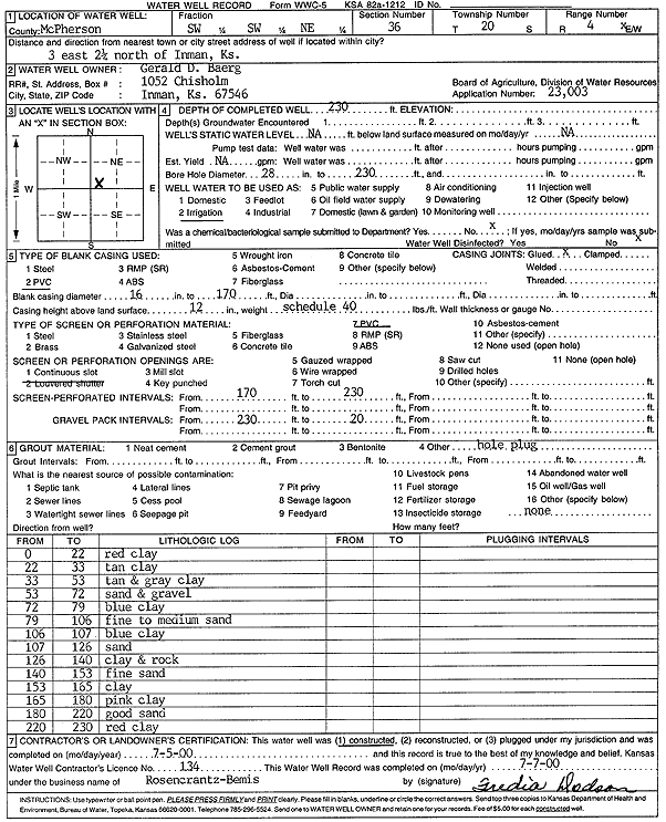
Specific Water Well Detail |
|
|
| Location Info | |||
| Owner: Baerg, Gerald D. | Status: Constructed | ||
| Location: T20S, R4W, Sec. 36, SW SW NE | County: McPherson | ||
| Directions: from Inman: 3 mi E, 2.25 mi N | |||
| Latitude: 38.2687804 | Longitude: -97.7115371 | Datum NAD 27 | |
| Latitude: 38.2687893 | Longitude: -97.7118604 | Datum NAD 83 | |
| Longitude and latitude calculated by Survey from township-range-section-quarter calls. Only good to within the quarter call accuracy. | |||
| View well on interactive map | |||
| General Info | ||
| Well Depth: 230 ft. | Elevation: ft. | |
| Static Water Level: ft. | Est. Yield: gpm. | |
| Comp. Date: 05-Jul-2000 | Well Use: Irrigation | |
| DWR Applic. #: 23003 | Other ID: | |
| Links | |
| No Wizard information available. | |
| View info from WIMAS Water Right Data base... | |
| Driller Info | ||
| Driller: Rosencrantz-Bemis Enterprises, Inc. | License #: 134 | |
| Scanned Form | View scan |
|
Chemical Sample Submitted?:
Water Well disinfected?: | ||
| Casing Info | ||
| Casing Type:
Casing Joints: |
Diam: in. to ft | |
| Casing height above land surface: in
Casing Weight: lbs/ft Wall thickness or gauge no.: | ||
| Screen and Perforation Info | ||
| Screen Type: | Screen Openings: | |
| Screen-perforated intervals | From: ft to ft | |
| Gravel pack intervals | From: ft to ft | |
| Grout Info | ||
| Grout used: | From: to ft | |
| Source of Possible Contamination | ||
| Source: | ||
| Direction from well: | Distance: ft | |
| Lithologic Log
(Log data entered by KGS.) | ||
| From: 0 ft. to 22 ft. | red clay | |
| From: 22 ft. to 33 ft. | tan clay | |
| From: 33 ft. to 53 ft. | tan and gray clay | |
| From: 53 ft. to 72 ft. | sand and gravel | |
| From: 72 ft. to 79 ft. | blue clay | |
| From: 79 ft. to 106 ft. | fine to medium sand | |
| From: 106 ft. to 107 ft. | blue clay | |
| From: 107 ft. to 126 ft. | sand | |
| From: 126 ft. to 140 ft. | clay and rock | |
| From: 140 ft. to 153 ft. | fine sand | |
| From: 153 ft. to 165 ft. | clay | |
| From: 165 ft. to 180 ft. | pink clay | |
| From: 180 ft. to 220 ft. | good sand | |
| From: 220 ft. to 230 ft. | red clay | |