|
|
|
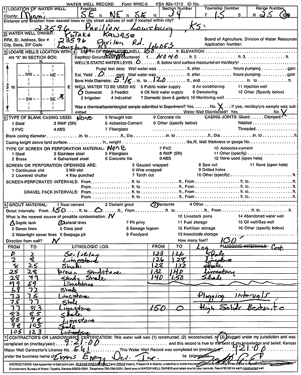
Specific Water Well Detail |
|
|
| Location Info | |||
| Owner: Kawase, Yutaka | Status: Constructed | ||
| Location: T15S, R25E, Sec. 34, SE NE SE | County: Miami | ||
| Directions: 23596 Pavilion, Louisburg | |||
| Latitude: 38.6990309 | Longitude: -94.6130288 | Datum NAD 27 | |
| Latitude: 38.6990409 | Longitude: -94.613262 | Datum NAD 83 | |
| Longitude and latitude calculated by Survey from township-range-section-quarter calls. Only good to within the quarter call accuracy. | |||
| View well on interactive map | |||
| General Info | ||
| Well Depth: 150 ft. | Elevation: ft. | |
| Static Water Level: ft. | Est. Yield: gpm. | |
| Comp. Date: 21-Sep-2000 | Well Use: Heat Pump (Closed Loop/Disposal), Geothermal | |
| DWR Applic. #: | Other ID: | |
| Driller Info | ||
| Driller: Evans Energy Development, Inc. | License #: 561 | |
| Scanned Form | View scan |
|
Chemical Sample Submitted?:
Water Well disinfected?: | ||
| Casing Info | ||
| Casing Type:
Casing Joints: |
Diam: in. to ft | |
| Casing height above land surface: in
Casing Weight: lbs/ft Wall thickness or gauge no.: | ||
| Screen and Perforation Info | ||
| Screen Type: | Screen Openings: | |
| Screen-perforated intervals | From: ft to ft | |
| Gravel pack intervals | From: ft to ft | |
| Grout Info | ||
| Grout used: | From: to ft | |
| Source of Possible Contamination | ||
| Source: | ||
| Direction from well: | Distance: ft | |
| Lithologic Log
(Log data entered by KGS.) | ||
| From: 0 ft. to 2 ft. | soil and clay | |
| From: 2 ft. to 8 ft. | limestone | |
| From: 8 ft. to 25 ft. | shale | |
| From: 25 ft. to 28 ft. | sandstone, brown | |
| From: 28 ft. to 49 ft. | sandy shale | |
| From: 49 ft. to 59 ft. | limestone | |
| From: 59 ft. to 72 ft. | shale | |
| From: 72 ft. to 75 ft. | limestone | |
| From: 75 ft. to 77 ft. | shale | |
| From: 77 ft. to 83 ft. | limestone | |
| From: 83 ft. to 85 ft. | shale | |
| From: 85 ft. to 98 ft. | limestone | |
| From: 98 ft. to 105 ft. | shale | |
| From: 105 ft. to 123 ft. | limestone | |
| From: 123 ft. to 126 ft. | shale | |
| From: 126 ft. to 128 ft. | limestone | |
| From: 128 ft. to 132 ft. | shale | |
| From: 132 ft. to 140 ft. | limestone | |
| From: 140 ft. to 150 ft. | shale | |