|
|
|
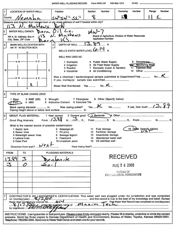
Specific Water Well Detail |
|
|
| Location Info | |||
| Owner: Bern Oil Co. | Status: Plugged | ||
| Location: T1S, R11E, Sec. 8, SW SW SE | County: Nemaha | ||
| Directions: 113 N Mathews, Bern | |||
| Latitude: 39.9731576 | Longitude: -96.2096013 | Datum NAD 27 | |
| Latitude: 39.9731576 | Longitude: -96.2098877 | Datum NAD 83 | |
| Longitude and latitude calculated by Survey from township-range-section-quarter calls. Only good to within the quarter call accuracy. | |||
| View well on interactive map | |||
| General Info | ||
| Well Depth: 13.89 ft. | Elevation: ft. | |
| Static Water Level: 6.14 ft. | Est. Yield: gpm. | |
| Comp. Date: 02-Aug-2000 | Well Use: Monitoring well/observation/piezometer | |
| DWR Applic. #: | Other ID: MW 7 | |
| Driller Info | ||
| Driller: Maxim Technologies, Inc. | License #: 614 | |
| Scanned Form | View scan |
| Casing Info | ||
|
Casing Type:
Diam: in. Casing height above land surface: in | ||
| Grout Info | ||
| Grout used: | From: to ft | |
| Source of Possible Contamination | ||
| Source: | ||
| Direction from well: | Distance: ft | |