|
|
|
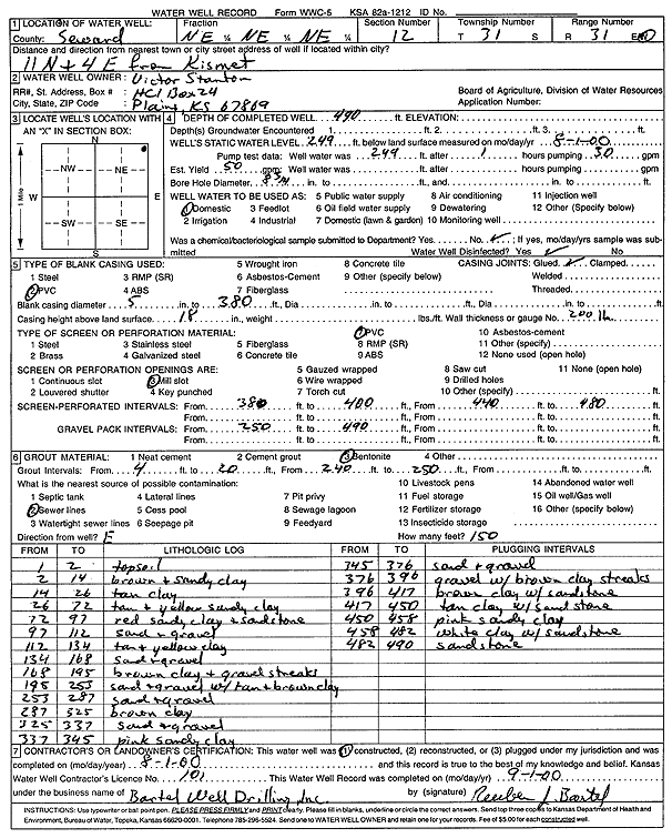
Specific Water Well Detail |
|
|
| Location Info | |||
| Owner: Stanton, Victor | Status: Constructed | ||
| Location: T31S, R31W, Sec. 12, NE NE NE | County: Seward | ||
| Directions: from Kismet: 11 mi N, 4 mi E | |||
| Latitude: 37.3722326 | Longitude: -100.6350591 | Datum NAD 27 | |
| Latitude: 37.3722553 | Longitude: -100.6354915 | Datum NAD 83 | |
| Longitude and latitude calculated by Survey from township-range-section-quarter calls. Only good to within the quarter call accuracy. | |||
| View well on interactive map | |||
| General Info | ||
| Well Depth: 490 ft. | Elevation: ft. | |
| Static Water Level: 249 ft. | Est. Yield: 50 gpm. | |
| Comp. Date: 01-Aug-2000 | Well Use: Domestic | |
| DWR Applic. #: | Other ID: | |
| Driller Info | ||
| Driller: Reuben Bartel Well Drilling, Inc. | License #: 101 | |
| Scanned Form | View scan |
|
Chemical Sample Submitted?:
Water Well disinfected?: | ||
| Casing Info | ||
| Casing Type:
Casing Joints: |
Diam: in. to ft | |
| Casing height above land surface: in
Casing Weight: lbs/ft Wall thickness or gauge no.: | ||
| Screen and Perforation Info | ||
| Screen Type: | Screen Openings: | |
| Screen-perforated intervals | From: ft to ft | |
| Gravel pack intervals | From: ft to ft | |
| Grout Info | ||
| Grout used: | From: to ft | |
| Source of Possible Contamination | ||
| Source: | ||
| Direction from well: | Distance: ft | |
| Lithologic Log
(Log data entered by KGS.) | ||
| From: 1 ft. to 2 ft. | topsoil | |
| From: 2 ft. to 14 ft. | brown and sandy clay | |
| From: 14 ft. to 26 ft. | tan clay | |
| From: 26 ft. to 72 ft. | tan and yellow sandy clay | |
| From: 72 ft. to 97 ft. | red sandy clay and sandstone | |
| From: 97 ft. to 112 ft. | sand and gravel | |
| From: 112 ft. to 134 ft. | tan and yellow clay | |
| From: 134 ft. to 168 ft. | sand and gravel | |
| From: 168 ft. to 195 ft. | brown clay and gravel streaks | |
| From: 195 ft. to 253 ft. | sand and gravel with tan and brown clay | |
| From: 253 ft. to 287 ft. | sand and gravel | |
| From: 287 ft. to 325 ft. | brown clay | |
| From: 325 ft. to 337 ft. | sand and gravel | |
| From: 337 ft. to 345 ft. | pink sandy clay | |
| From: 345 ft. to 376 ft. | sand and gravel | |
| From: 376 ft. to 396 ft. | gravel with brown clay streaks | |
| From: 396 ft. to 417 ft. | brown clay with sandstone | |
| From: 417 ft. to 450 ft. | tan clay with sandstone | |
| From: 450 ft. to 458 ft. | pink sandy clay | |
| From: 458 ft. to 482 ft. | white clay with sandstone | |
| From: 482 ft. to 490 ft. | sandstone | |