|
|
|
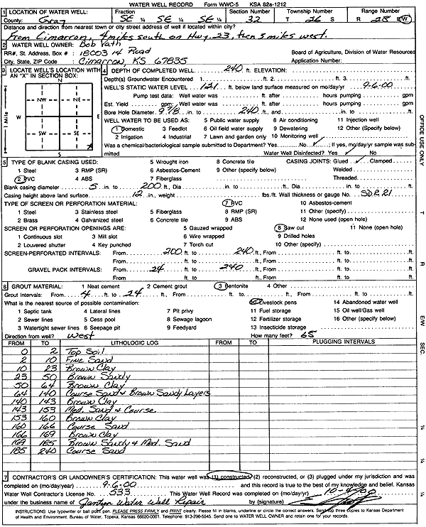
Specific Water Well Detail |
|
|
| Location Info | |||
| Owner: Vath, Bob | Status: Constructed | ||
| Location: T26S, R28W, Sec. 32, SE SE SE | County: Gray | ||
| Directions: from Cimarron: 4 mi S on Hwy 23, 3 mi W | |||
| Latitude: 37.7381557 | Longitude: -100.3977854 | Datum NAD 27 | |
| Latitude: 37.738178 | Longitude: -100.3982103 | Datum NAD 83 | |
| Longitude and latitude calculated by Survey from township-range-section-quarter calls. Only good to within the quarter call accuracy. | |||
| View well on interactive map | |||
| General Info | ||
| Well Depth: 240 ft. | Elevation: ft. | |
| Static Water Level: 121 ft. | Est. Yield: gpm. | |
| Comp. Date: 06-Sep-2000 | Well Use: Domestic | |
| DWR Applic. #: | Other ID: | |
| Driller Info | ||
| Driller: Ed Jantzen Water Well Repair | License #: 533 | |
| Scanned Form | View scan |
|
Chemical Sample Submitted?:
Water Well disinfected?: | ||
| Casing Info | ||
| Casing Type:
Casing Joints: |
Diam: in. to ft | |
| Casing height above land surface: in
Casing Weight: lbs/ft Wall thickness or gauge no.: | ||
| Screen and Perforation Info | ||
| Screen Type: | Screen Openings: | |
| Screen-perforated intervals | From: ft to ft | |
| Gravel pack intervals | From: ft to ft | |
| Grout Info | ||
| Grout used: | From: to ft | |
| Source of Possible Contamination | ||
| Source: | ||
| Direction from well: | Distance: ft | |
| Lithologic Log
(Log data entered by KGS.) | ||
| From: 0 ft. to 2 ft. | Top Soil | |
| From: 2 ft. to 10 ft. | Fine Sand | |
| From: 10 ft. to 23 ft. | Brown Clay | |
| From: 23 ft. to 50 ft. | Brown Sandy | |
| From: 50 ft. to 64 ft. | Brown Clay | |
| From: 64 ft. to 140 ft. | Coarse Sand and Brown Sandy Layers | |
| From: 140 ft. to 143 ft. | Brown Clay | |
| From: 143 ft. to 153 ft. | Medium and coarse sand | |
| From: 153 ft. to 160 ft. | Brown Clay | |
| From: 160 ft. to 166 ft. | Coarse Sand | |
| From: 166 ft. to 169 ft. | Brown Clay | |
| From: 169 ft. to 185 ft. | Brown Sandy and Medium Sand | |
| From: 185 ft. to 240 ft. | Coarse Sand | |