|
|
|
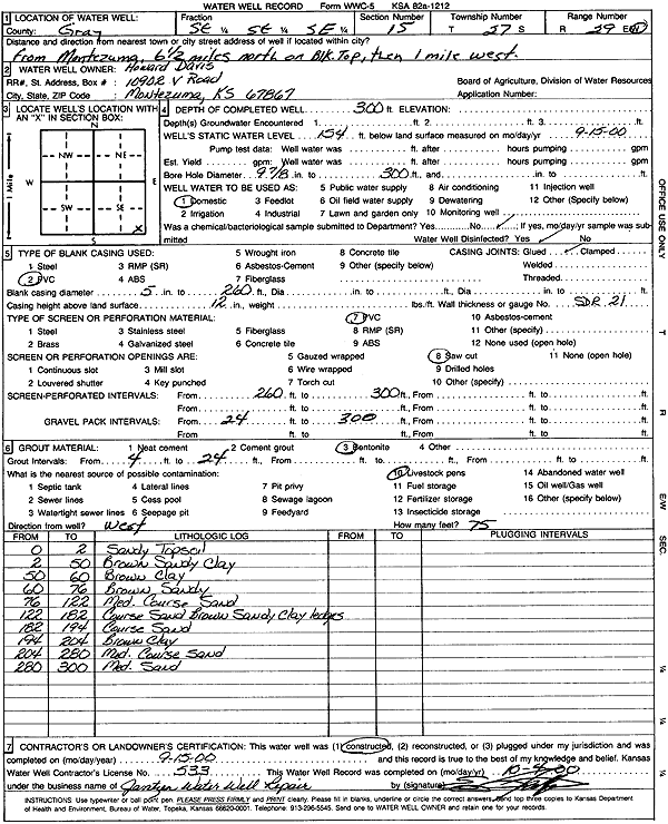
Specific Water Well Detail |
|
|
| Location Info | |||
| Owner: Davis, Howard | Status: Constructed | ||
| Location: T27S, R29W, Sec. 15, SE SE SE | County: Gray | ||
| Directions: from Montezuma: 6.5 mi N on black top, 1 mi W | |||
| Latitude: 37.6940714 | Longitude: -100.4707688 | Datum NAD 27 | |
| Latitude: 37.6940941 | Longitude: -100.4711965 | Datum NAD 83 | |
| Longitude and latitude calculated by Survey from township-range-section-quarter calls. Only good to within the quarter call accuracy. | |||
| View well on interactive map | |||
| General Info | ||
| Well Depth: 300 ft. | Elevation: ft. | |
| Static Water Level: 154 ft. | Est. Yield: gpm. | |
| Comp. Date: 15-Sep-2000 | Well Use: Domestic | |
| DWR Applic. #: | Other ID: | |
| Driller Info | ||
| Driller: Ed Jantzen Water Well Repair | License #: 533 | |
| Scanned Form | View scan |
|
Chemical Sample Submitted?:
Water Well disinfected?: | ||
| Casing Info | ||
| Casing Type:
Casing Joints: |
Diam: in. to ft | |
| Casing height above land surface: in
Casing Weight: lbs/ft Wall thickness or gauge no.: | ||
| Screen and Perforation Info | ||
| Screen Type: | Screen Openings: | |
| Screen-perforated intervals | From: ft to ft | |
| Gravel pack intervals | From: ft to ft | |
| Grout Info | ||
| Grout used: | From: to ft | |
| Source of Possible Contamination | ||
| Source: | ||
| Direction from well: | Distance: ft | |
| Lithologic Log
(Log data entered by KGS.) | ||
| From: 0 ft. to 2 ft. | Sandy Topsoil | |
| From: 2 ft. to 50 ft. | Brown Sandy Clay | |
| From: 50 ft. to 60 ft. | Brown Clay | |
| From: 60 ft. to 76 ft. | Brown Sandy | |
| From: 76 ft. to 122 ft. | Medium coarse Sand | |
| From: 122 ft. to 182 ft. | Coarse Sand Brown Sandy Clay ledges | |
| From: 182 ft. to 194 ft. | Coarse Sand | |
| From: 194 ft. to 204 ft. | Brown Clay | |
| From: 204 ft. to 280 ft. | Medium coarse Sand | |
| From: 280 ft. to 300 ft. | Medium Sand | |