|
|
|
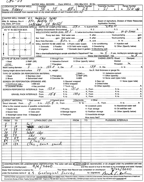
Specific Water Well Detail |
|
|
| Location Info | |||
| Owner: U.S. Geological Survey | Status: Constructed | ||
| Location: T21S, R32W, Sec. 28, SE SE NE | County: Finney | ||
| Directions: | |||
| Latitude: 38.2005122 | Longitude: -100.8299455 | Datum NAD 27 | |
| Latitude: 38.2005339 | Longitude: -100.8303791 | Datum NAD 83 | |
| Longitude and latitude calculated by Survey from township-range-section-quarter calls. Only good to within the quarter call accuracy. | |||
| View well on interactive map | |||
| General Info | ||
| Well Depth: 139 ft. | Elevation: 2920 ft. | |
| Static Water Level: 115.5 ft. | Est. Yield: gpm. | |
| Comp. Date: 04-Apr-2000 | Well Use: Monitoring well/observation/piezometer | |
| DWR Applic. #: | Other ID: | |
| Driller Info | ||
| Driller: U.S. Geological Survey | License #: | |
| Scanned Form | View scan |
|
Chemical Sample Submitted?:
Water Well disinfected?: | ||
| Casing Info | ||
| Casing Type:
Casing Joints: |
Diam: in. to ft | |
| Casing height above land surface: in
Casing Weight: lbs/ft Wall thickness or gauge no.: | ||
| Screen and Perforation Info | ||
| Screen Type: | Screen Openings: | |
| Screen-perforated intervals | From: ft to ft | |
| Gravel pack intervals | From: ft to ft | |
| Grout Info | ||
| Grout used: | From: to ft | |
| Source of Possible Contamination | ||
| Source: | ||
| Direction from well: | Distance: ft | |
| Lithologic Log
(Log data entered by KGS.) | ||
| From: 0 ft. to 9 ft. | soil | |
| From: 9 ft. to 19 ft. | caliche | |
| From: 19 ft. to 29 ft. | clay | |
| From: 29 ft. to 54 ft. | sandy clay | |
| From: 54 ft. to 79 ft. | clay | |
| From: 79 ft. to 89 ft. | sandy clay | |
| From: 89 ft. to 119 ft. | clay | |
| From: 119 ft. to 139 ft. | clay, some sand | |