|
|
|
Specific Water Well Detail |
|
|
| Location Info | |||
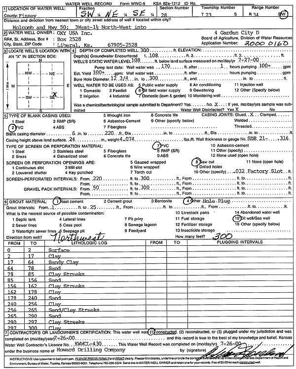
| Owner: Oxy USA, Inc. | Status: Constructed | ||
| Location: T23S, R34W, Sec. 28, SW NE SE | County: Finney | ||
| Directions: from Holcomb and Hwy 50: 3 mi W, 1.25 mi N, W into site | |||
| Latitude: 38.0223642 | Longitude: -101.0509414 | Datum NAD 27 | |
| Latitude: 38.0223877 | Longitude: -101.0513858 | Datum NAD 83 | |
| Longitude and latitude calculated by Survey from township-range-section-quarter calls. Only good to within the quarter call accuracy. | |||
| View well on interactive map | |||
| General Info | ||
| Well Depth: 300 ft. | Elevation: ft. | |
| Static Water Level: 108 ft. | Est. Yield: gpm. | |
| Comp. Date: 26-Jul-2000 | Well Use: Oil Field Water Supply | |
| DWR Applic. #: 20000160 | Other ID: Garden City U 1 | |
| Links | |
| No Wizard information available. | |
| View info from WIMAS Water Right Data base... | |
| Driller Info | ||
| Driller: Howard Drilling Company AG, LLC | License #: 430 | |
| Scanned Form | View scan |
|
Chemical Sample Submitted?:
Water Well disinfected?: | ||
| Casing Info | ||
| Casing Type:
Casing Joints: |
Diam: in. to ft | |
| Casing height above land surface: in
Casing Weight: lbs/ft Wall thickness or gauge no.: | ||
| Screen and Perforation Info | ||
| Screen Type: | Screen Openings: | |
| Screen-perforated intervals | From: ft to ft | |
| Gravel pack intervals | From: ft to ft | |
| Grout Info | ||
| Grout used: | From: to ft | |
| Source of Possible Contamination | ||
| Source: | ||
| Direction from well: | Distance: ft | |
| Lithologic Log
(Log data entered by KGS.) | ||
| From: 0 ft. to 2 ft. | surface | |
| From: 2 ft. to 17 ft. | clay | |
| From: 17 ft. to 64 ft. | sandy clay | |
| From: 64 ft. to 78 ft. | sand | |
| From: 78 ft. to 85 ft. | clay streaks | |
| From: 85 ft. to 156 ft. | sand | |
| From: 156 ft. to 162 ft. | clay streaks | |
| From: 162 ft. to 178 ft. | clay | |
| From: 178 ft. to 240 ft. | sand | |
| From: 240 ft. to 256 ft. | clay | |
| From: 256 ft. to 265 ft. | sand/clay streaks | |
| From: 265 ft. to 290 ft. | sand | |
| From: 290 ft. to 297 ft. | clay streaks | |
| From: 297 ft. to 300 ft. | clay | |