|
|
|
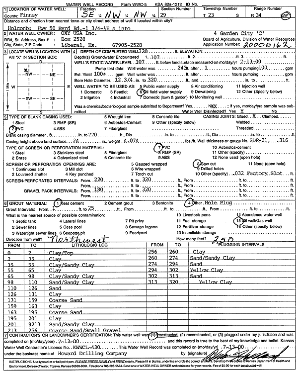
Specific Water Well Detail |
|
|
| Location Info | |||
| Owner: Oxy USA, Inc. | Status: Constructed | ||
| Location: T23S, R34W, Sec. 29, SE NW NW | County: Finney | ||
| Directions: from Holcomb: Hwy 50 and Byrd Rd; 1.75 mi N, 0.25 mi E, S into site | |||
| Latitude: 38.0294512 | Longitude: -101.0807988 | Datum NAD 27 | |
| Latitude: 38.0294741 | Longitude: -101.0812433 | Datum NAD 83 | |
| Longitude and latitude calculated by Survey from township-range-section-quarter calls. Only good to within the quarter call accuracy. | |||
| View well on interactive map | |||
| General Info | ||
| Well Depth: 320 ft. | Elevation: ft. | |
| Static Water Level: 107 ft. | Est. Yield: gpm. | |
| Comp. Date: 13-Jul-2000 | Well Use: Oil Field Water Supply | |
| DWR Applic. #: 20000162 | Other ID: Garden City C 4 | |
| Links | |
| No Wizard information available. | |
| View info from WIMAS Water Right Data base... | |
| Driller Info | ||
| Driller: Howard Drilling Company AG, LLC | License #: 430 | |
| Scanned Form | View scan |
|
Chemical Sample Submitted?:
Water Well disinfected?: | ||
| Casing Info | ||
| Casing Type:
Casing Joints: |
Diam: in. to ft | |
| Casing height above land surface: in
Casing Weight: lbs/ft Wall thickness or gauge no.: | ||
| Screen and Perforation Info | ||
| Screen Type: | Screen Openings: | |
| Screen-perforated intervals | From: ft to ft | |
| Gravel pack intervals | From: ft to ft | |
| Grout Info | ||
| Grout used: | From: to ft | |
| Source of Possible Contamination | ||
| Source: | ||
| Direction from well: | Distance: ft | |
| Lithologic Log
(Log data entered by KGS.) | ||
| From: 0 ft. to 2 ft. | clay/top | |
| From: 2 ft. to 35 ft. | clay | |
| From: 35 ft. to 55 ft. | clay/sandy clay | |
| From: 55 ft. to 65 ft. | clay | |
| From: 65 ft. to 98 ft. | clay/sandy clay | |
| From: 98 ft. to 110 ft. | sand/sandy clay | |
| From: 110 ft. to 126 ft. | sand | |
| From: 126 ft. to 131 ft. | clay | |
| From: 131 ft. to 159 ft. | coarse sand | |
| From: 159 ft. to 163 ft. | clay | |
| From: 163 ft. to 195 ft. | coarse sand | |
| From: 195 ft. to 201 ft. | clay | |
| From: 201 ft. to 213 ft. | sand/sandy clay | |
| From: 213 ft. to 256 ft. | coarse sand/small gravel | |
| From: 256 ft. to 260 ft. | clay | |
| From: 260 ft. to 274 ft. | sand/sandy clay | |
| From: 274 ft. to 294 ft. | sand | |
| From: 294 ft. to 302 ft. | yellow clay | |
| From: 302 ft. to 313 ft. | sand | |
| From: 313 ft. to 320 ft. | yellow clay | |