|
|
|
Specific Water Well Detail |
|
|
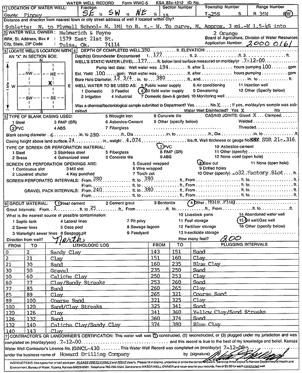
| Location Info | |||
| Owner: Helmerich and Payne Inc. | Status: Constructed | ||
| Location: T25S, R34W, Sec. 15, SE SW NE | County: Finney | ||
| Directions: N to Plymell School, 1 mi N to B.T., W to curve, 3 mi N, 1.5 mi W, .25 mi S | |||
| Latitude: 37.8810936 | Longitude: -101.0347352 | Datum NAD 27 | |
| Latitude: 37.881117 | Longitude: -101.0351811 | Datum NAD 83 | |
| Longitude and latitude calculated by Survey from township-range-section-quarter calls. Only good to within the quarter call accuracy. | |||
| View well on interactive map | |||
| General Info | ||
| Well Depth: 380 ft. | Elevation: ft. | |
| Static Water Level: 177 ft. | Est. Yield: gpm. | |
| Comp. Date: 12-Jul-2000 | Well Use: Oil Field Water Supply | |
| DWR Applic. #: 20000161 | Other ID: Orange 2 | |
| Links | |
| No Wizard information available. | |
| View info from WIMAS Water Right Data base... | |
| Driller Info | ||
| Driller: Howard Drilling Company AG, LLC | License #: 430 | |
| Scanned Form | View scan |
|
Chemical Sample Submitted?:
Water Well disinfected?: | ||
| Casing Info | ||
| Casing Type:
Casing Joints: |
Diam: in. to ft | |
| Casing height above land surface: in
Casing Weight: lbs/ft Wall thickness or gauge no.: | ||
| Screen and Perforation Info | ||
| Screen Type: | Screen Openings: | |
| Screen-perforated intervals | From: ft to ft | |
| Gravel pack intervals | From: ft to ft | |
| Grout Info | ||
| Grout used: | From: to ft | |
| Source of Possible Contamination | ||
| Source: | ||
| Direction from well: | Distance: ft | |
| Lithologic Log
(Log data entered by KGS.) | ||
| From: 2 ft. to 21 ft. | clay | |
| From: 21 ft. to 30 ft. | sand | |
| From: 30 ft. to 50 ft. | gravel | |
| From: 50 ft. to 60 ft. | caliche clay | |
| From: 60 ft. to 77 ft. | clay/sandy streaks | |
| From: 77 ft. to 85 ft. | sand | |
| From: 85 ft. to 89 ft. | clay | |
| From: 89 ft. to 100 ft. | coarse sand | |
| From: 100 ft. to 120 ft. | sand/clay streaks | |
| From: 120 ft. to 126 ft. | clay | |
| From: 126 ft. to 132 ft. | sand | |
| From: 132 ft. to 140 ft. | caliche clay/sandy clay | |
| From: 140 ft. to 143 ft. | clay | |
| From: 143 ft. to 151 ft. | sand | |
| From: 151 ft. to 160 ft. | clay | |
| From: 160 ft. to 235 ft. | blue clay | |
| From: 235 ft. to 250 ft. | sand | |
| From: 250 ft. to 253 ft. | clay | |
| From: 253 ft. to 260 ft. | sand | |
| From: 260 ft. to 265 ft. | clay | |
| From: 265 ft. to 321 ft. | coarse sand | |
| From: 321 ft. to 325 ft. | clay | |
| From: 325 ft. to 341 ft. | sand | |
| From: 341 ft. to 360 ft. | yellow clay/sand streaks | |
| From: 360 ft. to 374 ft. | sand | |
| From: 374 ft. to 380 ft. | blue clay | |