|
|
|
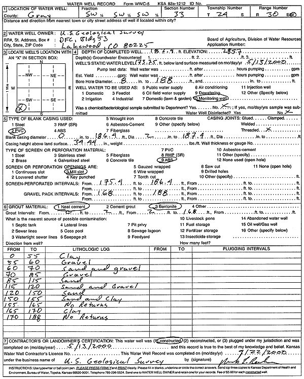
Specific Water Well Detail |
|
|
| Location Info | |||
| Owner: U.S. Geological Survey | Status: Constructed | ||
| Location: T24S, R30W, Sec. 33, SW SW SW | County: Gray | ||
| Directions: | |||
| Latitude: 37.9161681 | Longitude: -100.6269077 | Datum NAD 27 | |
| Latitude: 37.91619 | Longitude: -100.6273387 | Datum NAD 83 | |
| Longitude and latitude calculated by Survey from township-range-section-quarter calls. Only good to within the quarter call accuracy. | |||
| View well on interactive map | |||
| General Info | ||
| Well Depth: 187.4 ft. | Elevation: 2857 ft. | |
| Static Water Level: 173.8 ft. | Est. Yield: gpm. | |
| Comp. Date: 13-May-2000 | Well Use: Monitoring well/observation/piezometer | |
| DWR Applic. #: | Other ID: | |
| Driller Info | ||
| Driller: USGS | License #: | |
| Scanned Form | View scan |
|
Chemical Sample Submitted?:
Water Well disinfected?: | ||
| Casing Info | ||
| Casing Type:
Casing Joints: |
Diam: in. to ft | |
| Casing height above land surface: in
Casing Weight: lbs/ft Wall thickness or gauge no.: | ||
| Screen and Perforation Info | ||
| Screen Type: | Screen Openings: | |
| Screen-perforated intervals | From: ft to ft | |
| Gravel pack intervals | From: ft to ft | |
| Grout Info | ||
| Grout used: | From: to ft | |
| Source of Possible Contamination | ||
| Source: | ||
| Direction from well: | Distance: ft | |
| Lithologic Log
(Log data entered by KGS.) | ||
| From: 0 ft. to 55 ft. | Clay | |
| From: 55 ft. to 60 ft. | Gravel | |
| From: 60 ft. to 70 ft. | Sand and gravel | |
| From: 70 ft. to 85 ft. | Gravel | |
| From: 85 ft. to 115 ft. | Sand | |
| From: 115 ft. to 120 ft. | Sand and Gravel | |
| From: 120 ft. to 150 ft. | Sand | |
| From: 150 ft. to 155 ft. | Sand and Clay | |
| From: 155 ft. to 165 ft. | No Returns | |
| From: 165 ft. to 170 ft. | Clay | |
| From: 170 ft. to 188 ft. | No Returns | |