|
|
|
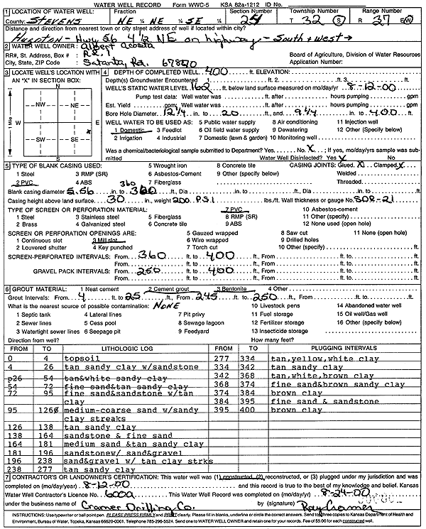
Specific Water Well Detail |
|
|
| Location Info | |||
| Owner: Acosta, Albert | Status: Constructed | ||
| Location: T32S, R37W, Sec. 24, NE NE SE | County: Stevens | ||
| Directions: from Hugoton: 4.5 mi NE on Hwy 56, S and W into site | |||
| Latitude: 37.2488799 | Longitude: -101.2854101 | Datum NAD 27 | |
| Latitude: 37.2489039 | Longitude: -101.2858443 | Datum NAD 83 | |
| Longitude and latitude calculated by Survey from township-range-section-quarter calls. Only good to within the quarter call accuracy. | |||
| View well on interactive map | |||
| General Info | ||
| Well Depth: 40 ft. | Elevation: ft. | |
| Static Water Level: 162 ft. | Est. Yield: gpm. | |
| Comp. Date: 12-Aug-2000 | Well Use: Domestic | |
| DWR Applic. #: | Other ID: | |
| Driller Info | ||
| Driller: Cramer Drilling Co. | License #: | |
| Scanned Form | View scan |
|
Chemical Sample Submitted?:
Water Well disinfected?: | ||
| Casing Info | ||
| Casing Type:
Casing Joints: |
Diam: in. to ft | |
| Casing height above land surface: in
Casing Weight: lbs/ft Wall thickness or gauge no.: | ||
| Screen and Perforation Info | ||
| Screen Type: | Screen Openings: | |
| Screen-perforated intervals | From: ft to ft | |
| Gravel pack intervals | From: ft to ft | |
| Grout Info | ||
| Grout used: | From: to ft | |
| Source of Possible Contamination | ||
| Source: | ||
| Direction from well: | Distance: ft | |
| Lithologic Log
(Log data entered by KGS.) | ||
| From: 0 ft. to 4 ft. | topsoil | |
| From: 4 ft. to 26 ft. | tan sandy clay with sandstone | |
| From: 26 ft. to 54 ft. | tan and white sandy clay | |
| From: 54 ft. to 72 ft. | fine sand and tan sandy clay | |
| From: 72 ft. to 95 ft. | fine sand and sandstone with tan clay | |
| From: 95 ft. to 126 ft. | medium-coarse sand with sandy clay streaks | |
| From: 126 ft. to 138 ft. | tan sandy clay | |
| From: 138 ft. to 164 ft. | sandstone and fine sand | |
| From: 164 ft. to 181 ft. | medium sand and tan sandy clay | |
| From: 181 ft. to 196 ft. | sandstone with sand and gravel | |
| From: 196 ft. to 238 ft. | sand and gravel with tan clay streaks | |
| From: 238 ft. to 277 ft. | tan sandy clay | |
| From: 277 ft. to 334 ft. | tan, yellow, white clay | |
| From: 334 ft. to 342 ft. | tan sandy clay | |
| From: 342 ft. to 368 ft. | tan, white, brown clay | |
| From: 368 ft. to 374 ft. | fine sand and brown sandy clay | |
| From: 374 ft. to 384 ft. | brown clay | |
| From: 384 ft. to 395 ft. | fine sand and sandstone | |
| From: 395 ft. to 400 ft. | brown clay | |