|
|
|
Specific Water Well Detail |
|
|
| Location Info | |||
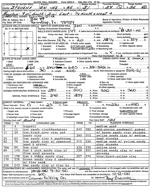
| Owner: Dick, Dorthy | Status: Constructed | ||
| Location: T34S, R36W, Sec. 31, SW NE SE | County: Stevens | ||
| Directions: From Hugoton, 9 miles South, 3 miles East, 0.25 mile North, and West into site | |||
| Latitude: 37.0440607 | Longitude: -101.2690002 | Datum NAD 27 | |
| Latitude: 37.0440865 | Longitude: -101.2694392 | Datum NAD 83 | |
| Longitude and latitude calculated by Survey from township-range-section-quarter calls. Only good to within the quarter call accuracy. | |||
| View well on interactive map | |||
| General Info | ||
| Well Depth: 360 ft. | Elevation: ft. | |
| Static Water Level: 147 ft. | Est. Yield: gpm. | |
| Comp. Date: 30-Sep-2000 | Well Use: Oil Field Water Supply | |
| DWR Applic. #: | Other ID: | |
| Links | |
| No Wizard information available. | |
| View info from WIMAS Water Right Data base... | |
| Driller Info | ||
| Driller: Ray Cramer Drilling Co. | License #: 600 | |
| Scanned Form | View scan |
|
Chemical Sample Submitted?:
Water Well disinfected?: | ||
| Casing Info | ||
| Casing Type:
Casing Joints: |
Diam: in. to ft | |
| Casing height above land surface: in
Casing Weight: lbs/ft Wall thickness or gauge no.: | ||
| Screen and Perforation Info | ||
| Screen Type: | Screen Openings: | |
| Screen-perforated intervals | From: ft to ft | |
| Gravel pack intervals | From: ft to ft | |
| Grout Info | ||
| Grout used: | From: to ft | |
| Source of Possible Contamination | ||
| Source: | ||
| Direction from well: | Distance: ft | |
| Lithologic Log
(Log data entered by KGS.) | ||
| From: 0 ft. to 4 ft. | topsoil | |
| From: 4 ft. to 11 ft. | tan sandy clay and sandstone | |
| From: 11 ft. to 24 ft. | tan, black, gray clay and sandy clay | |
| From: 24 ft. to 62 ft. | tan sandy clay and sandstone | |
| From: 62 ft. to 76 ft. | tan sandy clay with cemented sand and gravel | |
| From: 76 ft. to 89 ft. | tan clay | |
| From: 89 ft. to 143 ft. | tan and pink sandy clay with fine sand streaks | |
| From: 143 ft. to 178 ft. | tan and white sandy clay | |
| From: 178 ft. to 226 ft. | brown sandy clay and sandstone with fine sand | |
| From: 226 ft. to 243 ft. | tan sandy clay with fine to medium sand | |
| From: 243 ft. to 292 ft. | med-coarse sand small gravel with brown sandy clay streaks | |
| From: 292 ft. to 315 ft. | yellow sandy clay with medium sand streaks | |
| From: 315 ft. to 334 ft. | medium sand with yellow sandy clay streaks | |
| From: 334 ft. to 339 ft. | yellow clay | |
| From: 339 ft. to 357 ft. | yellow sandy clay with sand streaks | |
| From: 357 ft. to 374 ft. | blue, black, yellow clay | |