|
|
|
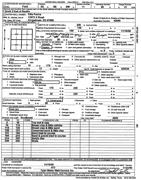
Specific Water Well Detail |
|
|
| Location Info | |||
| Owner: Ellis Farms | Status: Constructed | ||
| Location: T29S, R21W, Sec. 11, SE SE SW | County: Ford | ||
| Directions: from Bucklin: 1 mi S, 2 mi E | |||
| Latitude: 37.5283806 | Longitude: -99.5848944 | Datum NAD 27 | |
| Latitude: 37.5284013 | Longitude: -99.585294 | Datum NAD 83 | |
| Longitude and latitude calculated by Survey from township-range-section-quarter calls. Only good to within the quarter call accuracy. | |||
| View well on interactive map | |||
| General Info | ||
| Well Depth: 235 ft. | Elevation: ft. | |
| Static Water Level: 140 ft. | Est. Yield: gpm. | |
| Comp. Date: 15-Nov-2000 | Well Use: Irrigation | |
| DWR Applic. #: 43640 | Other ID: | |
| Links | |
| No Wizard information available. | |
| View info from WIMAS Water Right Data base... | |
| Driller Info | ||
| Driller: Destal Tyler Water Well Service | License #: 473 | |
| Scanned Form | View scan |
|
Chemical Sample Submitted?:
Water Well disinfected?: | ||
| Casing Info | ||
| Casing Type:
Casing Joints: |
Diam: in. to ft | |
| Casing height above land surface: in
Casing Weight: lbs/ft Wall thickness or gauge no.: | ||
| Screen and Perforation Info | ||
| Screen Type: | Screen Openings: | |
| Screen-perforated intervals | From: ft to ft | |
| Gravel pack intervals | From: ft to ft | |
| Grout Info | ||
| Grout used: | From: to ft | |
| Source of Possible Contamination | ||
| Source: | ||
| Direction from well: | Distance: ft | |
| Lithologic Log
(Log data entered by KGS.) | ||
| From: 0 ft. to 16 ft. | topsoil and clay | |
| From: 16 ft. to 114 ft. | brown clay and little caliche | |
| From: 114 ft. to 120 ft. | brown clay and little sand | |
| From: 120 ft. to 131 ft. | cemented sand and little clay | |
| From: 131 ft. to 164 ft. | sand medium to coarse | |
| From: 164 ft. to 214 ft. | sand and gravel medium to coarse | |
| From: 214 ft. to 229 ft. | sandy clay | |
| From: 229 ft. to 235 ft. | shale | |