|
|
|
Specific Water Well Detail |
|
|
| Location Info | |||
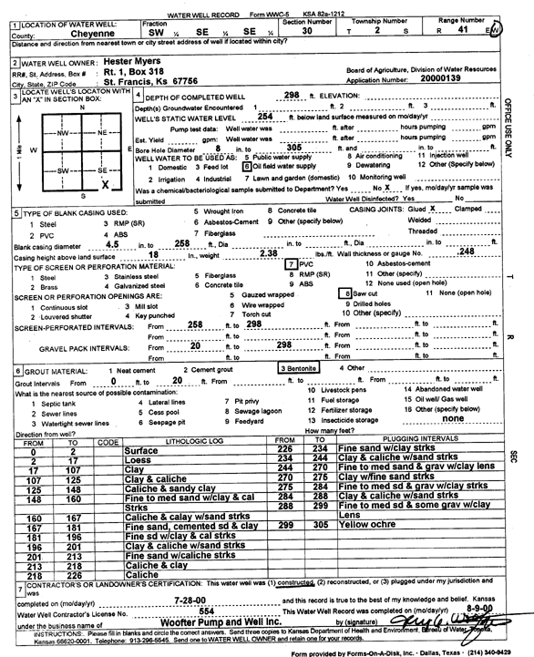
| Owner: Myers, Hester | Status: Constructed | ||
| Location: T2S, R41W, Sec. 30, SW SE SE | County: Cheyenne | ||
| Directions: | |||
| Latitude: 39.8443889 | Longitude: -101.9586947 | Datum NAD 27 | |
| Latitude: 39.8443811 | Longitude: -101.9591544 | Datum NAD 83 | |
| Longitude and latitude calculated by Survey from township-range-section-quarter calls. Only good to within the quarter call accuracy. | |||
| View well on interactive map | |||
| General Info | ||
| Well Depth: 298 ft. | Elevation: ft. | |
| Static Water Level: 254 ft. | Est. Yield: gpm. | |
| Comp. Date: 28-Jul-2000 | Well Use: Oil Field Water Supply | |
| DWR Applic. #: 20000139 | Other ID: | |
| Links | |
| No Wizard information available. | |
| View info from WIMAS Water Right Data base... | |
| Driller Info | ||
| Driller: Jay C. Woofter Pump & Well, Inc. | License #: 554 | |
| Scanned Form | View scan |
|
Chemical Sample Submitted?:
Water Well disinfected?: | ||
| Casing Info | ||
| Casing Type:
Casing Joints: |
Diam: in. to ft | |
| Casing height above land surface: in
Casing Weight: lbs/ft Wall thickness or gauge no.: | ||
| Screen and Perforation Info | ||
| Screen Type: | Screen Openings: | |
| Screen-perforated intervals | From: ft to ft | |
| Gravel pack intervals | From: ft to ft | |
| Grout Info | ||
| Grout used: | From: to ft | |
| Source of Possible Contamination | ||
| Source: | ||
| Direction from well: | Distance: ft | |
| Lithologic Log
(Log data entered by KGS.) | ||
| From: 0 ft. to 2 ft. | Surface | |
| From: 2 ft. to 17 ft. | Loess | |
| From: 17 ft. to 107 ft. | Clay | |
| From: 107 ft. to 125 ft. | Clay and caliche | |
| From: 125 ft. to 148 ft. | Caliche and sandy clay | |
| From: 148 ft. to 160 ft. | Fine to medium sand with clay and caliche streaks | |
| From: 160 ft. to 167 ft. | Caliche and clay with sand streaks | |
| From: 167 ft. to 181 ft. | Fine sand, cemented sand and clay | |
| From: 181 ft. to 196 ft. | Fine sand with clay and caliche streaks | |
| From: 196 ft. to 201 ft. | Clay and caliche with sand streaks | |
| From: 201 ft. to 213 ft. | Fine sand with caliche streaks | |
| From: 213 ft. to 218 ft. | Caliche and clay | |
| From: 218 ft. to 226 ft. | Caliche | |
| From: 226 ft. to 234 ft. | Fine sand with clay streaks | |
| From: 234 ft. to 244 ft. | Clay and caliche with sand streaks | |
| From: 244 ft. to 270 ft. | Fine to medium sand and gravel with clay lens | |
| From: 270 ft. to 275 ft. | Clay with fine sand streaks | |
| From: 275 ft. to 284 ft. | Fine to medium sand and gravel with clay streaks | |
| From: 284 ft. to 288 ft. | Clay and caliche with sand streaks | |
| From: 288 ft. to 299 ft. | Fine to medium sand and some gravel with clay lens | |
| From: 299 ft. to 305 ft. | Yellow ochre | |