|
|
|
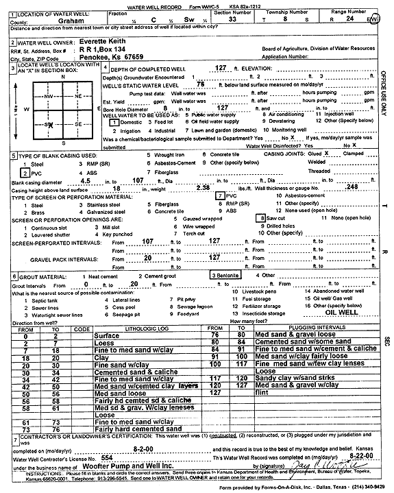
Specific Water Well Detail |
|
|
| Location Info | |||
| Owner: Keith, Everette | Status: Constructed | ||
| Location: T8S, R24W, Sec. 33, C SW | County: Graham | ||
| Directions: | |||
| Latitude: 39.3094165 | Longitude: -100.009237 | Datum NAD 27 | |
| Latitude: 39.3094213 | Longitude: -100.0096418 | Datum NAD 83 | |
| Longitude and latitude calculated by Survey from township-range-section-quarter calls. Only good to within the quarter call accuracy. | |||
| View well on interactive map | |||
| General Info | ||
| Well Depth: 127 ft. | Elevation: ft. | |
| Static Water Level: 76 ft. | Est. Yield: gpm. | |
| Comp. Date: 02-Aug-2000 | Well Use: Domestic | |
| DWR Applic. #: | Other ID: | |
| Driller Info | ||
| Driller: Jay C. Woofter Pump & Well, Inc. | License #: 554 | |
| Scanned Form | View scan |
|
Chemical Sample Submitted?:
Water Well disinfected?: | ||
| Casing Info | ||
| Casing Type:
Casing Joints: |
Diam: in. to ft | |
| Casing height above land surface: in
Casing Weight: lbs/ft Wall thickness or gauge no.: | ||
| Screen and Perforation Info | ||
| Screen Type: | Screen Openings: | |
| Screen-perforated intervals | From: ft to ft | |
| Gravel pack intervals | From: ft to ft | |
| Grout Info | ||
| Grout used: | From: to ft | |
| Source of Possible Contamination | ||
| Source: | ||
| Direction from well: | Distance: ft | |
| Lithologic Log
(Log data entered by KGS.) | ||
| From: 0 ft. to 2 ft. | surface | |
| From: 2 ft. to 7 ft. | loess | |
| From: 7 ft. to 18 ft. | fine to medium sand with clay | |
| From: 18 ft. to 20 ft. | clay | |
| From: 20 ft. to 30 ft. | fine sand with clay | |
| From: 30 ft. to 34 ft. | cemented sand and caliche | |
| From: 34 ft. to 42 ft. | fine to medium sand with clay | |
| From: 42 ft. to 50 ft. | medium sand with cemented clay layers | |
| From: 50 ft. to 56 ft. | medium sand loose | |
| From: 56 ft. to 58 ft. | fairly hard cemented sand and caliche | |
| From: 58 ft. to 61 ft. | medium sand and gravel with clay lenses loose | |
| From: 61 ft. to 73 ft. | fine to medium sand with clay | |
| From: 73 ft. to 76 ft. | fairly hard cemented sand | |
| From: 76 ft. to 80 ft. | medium sand and gravel loose | |
| From: 80 ft. to 84 ft. | cemented sand with some sand | |
| From: 84 ft. to 91 ft. | fine to medium sand with cement and caliche | |
| From: 91 ft. to 100 ft. | medium sand with clay fairly loose | |
| From: 100 ft. to 117 ft. | fine medium sand with few clay lenses loose | |
| From: 117 ft. to 120 ft. | sandy clay with sand streaks | |
| From: 120 ft. to 127 ft. | medium sand and gravel with clay | |
| From: 127 ft. to ft. | flint | |