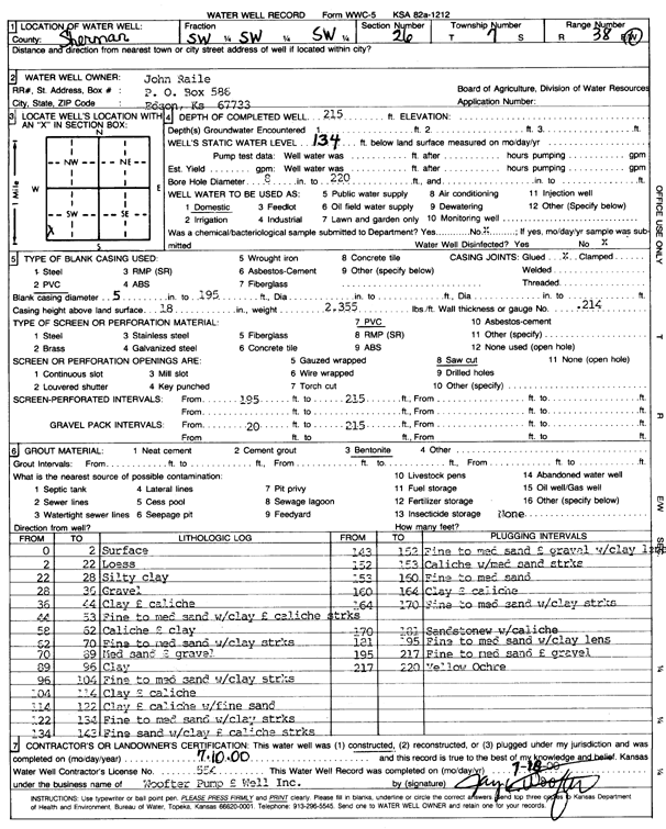
Lithologic Log
(Log data entered by KGS.) |
| |
From: 0 ft. to 2 ft. |
Surface |
| |
From: 2 ft. to 22 ft. |
Loess |
| |
From: 22 ft. to 28 ft. |
Silty clay |
| |
From: 28 ft. to 36 ft. |
Gravel |
| |
From: 36 ft. to 44 ft. |
Clay and caliche |
| |
From: 44 ft. to 58 ft. |
Fine to medium sand with clay and caliche streaks |
| |
From: 58 ft. to 62 ft. |
Caliche and clay |
| |
From: 62 ft. to 70 ft. |
Fine to medium sand with clay streaks |
| |
From: 70 ft. to 89 ft. |
Medium sand and gravel |
| |
From: 89 ft. to 96 ft. |
Clay |
| |
From: 96 ft. to 104 ft. |
Fine to medium sand with clay streaks |
| |
From: 104 ft. to 114 ft. |
Clay and caliche |
| |
From: 114 ft. to 122 ft. |
Clay and caliche with fine sand |
| |
From: 122 ft. to 134 ft. |
Fine to medium sand with clay streaks |
| |
From: 134 ft. to 143 ft. |
Fine sand with clay and caliche streaks |
| |
From: 143 ft. to 152 ft. |
Fine to medium sand and gravel with clay lens |
| |
From: 152 ft. to 153 ft. |
Caliche with medium sand streaks |
| |
From: 153 ft. to 160 ft. |
Fine to medium sand |
| |
From: 160 ft. to 164 ft. |
Clay and caliche |
| |
From: 164 ft. to 170 ft. |
Fine to medium sand with clay streaks |
| |
From: 170 ft. to 181 ft. |
Sandstone with caliche |
| |
From: 181 ft. to 195 ft. |
Fine to medium sand with clay lens |
| |
From: 195 ft. to 217 ft. |
Fine to medium sand and gravel |
| |
From: 217 ft. to 220 ft. |
Yellow ochre |