|
|
|
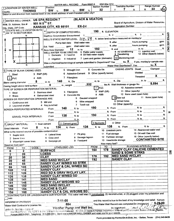
Specific Water Well Detail |
|
|
| Location Info | |||
| Owner: U.S. EPA Region 7 | Status: Constructed | ||
| Location: T7S, R33W, Sec. 32, SW SW SW | County: Thomas | ||
| Directions: | |||
| Latitude: 39.3952186 | Longitude: -101.0348394 | Datum NAD 27 | |
| Latitude: 39.3952223 | Longitude: -101.0352721 | Datum NAD 83 | |
| Longitude and latitude calculated by Survey from township-range-section-quarter calls. Only good to within the quarter call accuracy. | |||
| View well on interactive map | |||
| General Info | ||
| Well Depth: 190 ft. | Elevation: ft. | |
| Static Water Level: 110.8 ft. | Est. Yield: gpm. | |
| Comp. Date: 11-Jul-2000 | Well Use: Monitoring well/observation/piezometer | |
| DWR Applic. #: | Other ID: EX 2 I | |
| Driller Info | ||
| Driller: Jay C. Woofter Pump & Well, Inc. | License #: 554 | |
| Scanned Form | View scan |
|
Chemical Sample Submitted?:
Water Well disinfected?: | ||
| Casing Info | ||
| Casing Type:
Casing Joints: |
Diam: in. to ft | |
| Casing height above land surface: in
Casing Weight: lbs/ft Wall thickness or gauge no.: | ||
| Screen and Perforation Info | ||
| Screen Type: | Screen Openings: | |
| Screen-perforated intervals | From: ft to ft | |
| Gravel pack intervals | From: ft to ft | |
| Grout Info | ||
| Grout used: | From: to ft | |
| Source of Possible Contamination | ||
| Source: | ||
| Direction from well: | Distance: ft | |
| Lithologic Log
(Log data entered by KGS.) | ||
| From: 0 ft. to 2 ft. | surface | |
| From: 2 ft. to 20 ft. | loess | |
| From: 20 ft. to 30 ft. | clay | |
| From: 30 ft. to 45 ft. | medium sand with clay | |
| From: 45 ft. to 66 ft. | sandy clay with medium sand streak | |
| From: 66 ft. to 105 ft. | sandy clay and caliche with medium sand | |
| From: 105 ft. to 112 ft. | sandy clay | |
| From: 112 ft. to 126 ft. | medium sand and gravel with clay layers | |
| From: 126 ft. to 138 ft. | sandy clay with medium sand | |
| From: 138 ft. to 141 ft. | medium sand | |
| From: 141 ft. to 146 ft. | sandy clay with some sand | |
| From: 146 ft. to 150 ft. | medium sand with clay | |
| From: 150 ft. to 154 ft. | caliche and clay | |
| From: 154 ft. to 160 ft. | sandy clay and caliche with some sand | |
| From: 160 ft. to 178 ft. | sandy clay, caliche, cemented sand, and some streaks | |
| From: 178 ft. to 192 ft. | medium sand and clay | |
| From: 192 ft. to ft. | sandy clay | |