|
|
|
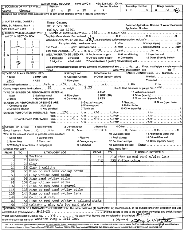
Specific Water Well Detail |
|
|
| Location Info | |||
| Owner: Carney, Ross | Status: Constructed | ||
| Location: T8S, R34W, Sec. 2, NW SW SW | County: Thomas | ||
| Directions: | |||
| Latitude: 39.3826655 | Longitude: -101.0906927 | Datum NAD 27 | |
| Latitude: 39.3826691 | Longitude: -101.0911265 | Datum NAD 83 | |
| Longitude and latitude calculated by Survey from township-range-section-quarter calls. Only good to within the quarter call accuracy. | |||
| View well on interactive map | |||
| General Info | ||
| Well Depth: 214 ft. | Elevation: ft. | |
| Static Water Level: 107 ft. | Est. Yield: gpm. | |
| Comp. Date: 23-Aug-2000 | Well Use: Domestic | |
| DWR Applic. #: | Other ID: | |
| Driller Info | ||
| Driller: Jay C. Woofter Pump & Well, Inc. | License #: 554 | |
| Scanned Form | View scan |
|
Chemical Sample Submitted?:
Water Well disinfected?: | ||
| Casing Info | ||
| Casing Type:
Casing Joints: |
Diam: in. to ft | |
| Casing height above land surface: in
Casing Weight: lbs/ft Wall thickness or gauge no.: | ||
| Screen and Perforation Info | ||
| Screen Type: | Screen Openings: | |
| Screen-perforated intervals | From: ft to ft | |
| Gravel pack intervals | From: ft to ft | |
| Grout Info | ||
| Grout used: | From: to ft | |
| Source of Possible Contamination | ||
| Source: | ||
| Direction from well: | Distance: ft | |
| Lithologic Log
(Log data entered by KGS.) | ||
| From: 0 ft. to 2 ft. | surface | |
| From: 2 ft. to 19 ft. | loess | |
| From: 19 ft. to 24 ft. | clay | |
| From: 24 ft. to 32 ft. | clay and caliche | |
| From: 32 ft. to 50 ft. | fine to medium sand with clay streaks | |
| From: 50 ft. to 65 ft. | clay with fine sand streaks | |
| From: 65 ft. to 91 ft. | fine sand with clay streaks | |
| From: 91 ft. to 107 ft. | clay with fine sand streaks | |
| From: 107 ft. to 115 ft. | fine to medium sand and gravel | |
| From: 115 ft. to 135 ft. | fine to medium sand with clay streaks | |
| From: 135 ft. to 144 ft. | fine to medium sand with clay lens | |
| From: 144 ft. to 147 ft. | caliche and clay | |
| From: 147 ft. to 154 ft. | caliche and clay | |
| From: 154 ft. to 171 ft. | caliche and clay with a few sand streaks | |
| From: 171 ft. to 210 ft. | fine to medium sand with clay lens | |
| From: 210 ft. to 220 ft. | yellow ochre | |