|
|
|
Specific Water Well Detail |
|
|
| Location Info | |||
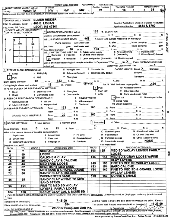
| Owner: Ridder, Elmer | Status: Constructed | ||
| Location: T18S, R35W, Sec. 21, NW NW NW | County: Wichita | ||
| Directions: | |||
| Latitude: 38.4809103 | Longitude: -101.2000995 | Datum NAD 27 | |
| Latitude: 38.4809306 | Longitude: -101.2005332 | Datum NAD 83 | |
| Longitude and latitude calculated by Survey from township-range-section-quarter calls. Only good to within the quarter call accuracy. | |||
| View well on interactive map | |||
| General Info | ||
| Well Depth: 163 ft. | Elevation: ft. | |
| Static Water Level: 145 ft. | Est. Yield: gpm. | |
| Comp. Date: 15-Jul-2000 | Well Use: Irrigation | |
| DWR Applic. #: 4688, 8700 | Other ID: | |
| Links | |
| No Wizard information available. | |
| View info from WIMAS Water Right Data base... | |
| Driller Info | ||
| Driller: Jay C. Woofter Pump & Well, Inc. | License #: 554 | |
| Scanned Form | View scan |
|
Chemical Sample Submitted?:
Water Well disinfected?: | ||
| Casing Info | ||
| Casing Type:
Casing Joints: |
Diam: in. to ft | |
| Casing height above land surface: in
Casing Weight: lbs/ft Wall thickness or gauge no.: | ||
| Screen and Perforation Info | ||
| Screen Type: | Screen Openings: | |
| Screen-perforated intervals | From: ft to ft | |
| Gravel pack intervals | From: ft to ft | |
| Grout Info | ||
| Grout used: | From: to ft | |
| Source of Possible Contamination | ||
| Source: | ||
| Direction from well: | Distance: ft | |
| Lithologic Log
(Log data entered by KGS.) | ||
| From: 0 ft. to 2 ft. | Surface | |
| From: 2 ft. to 10 ft. | Loess | |
| From: 10 ft. to 15 ft. | Caliche and clay | |
| From: 15 ft. to 40 ft. | Sandy clay and caliche | |
| From: 40 ft. to 43 ft. | Medium sand, loose | |
| From: 43 ft. to 52 ft. | Medium sand, semi tight | |
| From: 52 ft. to 73 ft. | Medium sand and gravel, loose | |
| From: 73 ft. to 86 ft. | Sandy clay and caliche with cemented sand | |
| From: 86 ft. to 95 ft. | Sandy clay with fine to medium sand streaks | |
| From: 95 ft. to 104 ft. | Fine to medium sand with clay layers, fairly loose | |
| From: 104 ft. to 108 ft. | Sandy clay, caliche, and some sand | |
| From: 108 ft. to 135 ft. | Medium sand with clay lenses, fairly loose | |
| From: 135 ft. to 145 ft. | Medium sand and gravel, loose, with fine clay layers | |
| From: 145 ft. to 153 ft. | Fine to medium sand with clay, loose | |
| From: 153 ft. to 154 ft. | Caliche, hard | |
| From: 154 ft. to 160 ft. | Fine to medium sand and gravel, loose, with clay lenses | |
| From: 160 ft. to 163 ft. | Ochre and caliche | |