|
|
|
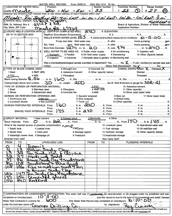
Specific Water Well Detail |
|
|
| Location Info | |||
| Owner: Frieson, Clifford | Status: Constructed | ||
| Location: T33S, R27W, Sec. 25, SW NW SW | County: Meade | ||
| Directions: from Meade: 8 mi S on 23, 4 mi E, 1 mi S, 1 mi E, 1 mi S, 1 mi E, .5 mi NE | |||
| Latitude: 37.1445332 | Longitude: -100.2163737 | Datum NAD 27 | |
| Latitude: 37.1445597 | Longitude: -100.2167936 | Datum NAD 83 | |
| Longitude and latitude calculated by Survey from township-range-section-quarter calls. Only good to within the quarter call accuracy. | |||
| View well on interactive map | |||
| General Info | ||
| Well Depth: 240 ft. | Elevation: ft. | |
| Static Water Level: 153 ft. | Est. Yield: gpm. | |
| Comp. Date: 05-Oct-2000 | Well Use: Domestic | |
| DWR Applic. #: | Other ID: | |
| Driller Info | ||
| Driller: Ray Cramer Drilling Co. | License #: 600 | |
| Scanned Form | View scan |
|
Chemical Sample Submitted?:
Water Well disinfected?: | ||
| Casing Info | ||
| Casing Type:
Casing Joints: |
Diam: in. to ft | |
| Casing height above land surface: in
Casing Weight: lbs/ft Wall thickness or gauge no.: | ||
| Screen and Perforation Info | ||
| Screen Type: | Screen Openings: | |
| Screen-perforated intervals | From: ft to ft | |
| Gravel pack intervals | From: ft to ft | |
| Grout Info | ||
| Grout used: | From: to ft | |
| Source of Possible Contamination | ||
| Source: | ||
| Direction from well: | Distance: ft | |
| Lithologic Log
(Log data entered by KGS.) | ||
| From: 0 ft. to 4 ft. | top soil | |
| From: 4 ft. to 13 ft. | brown sandy clay | |
| From: 13 ft. to 32 ft. | tan sandy clay and caliche | |
| From: 32 ft. to 37 ft. | medium sand | |
| From: 37 ft. to 86 ft. | brown sandy clay with sandstone | |
| From: 86 ft. to 108 ft. | sandstone and fine sand | |
| From: 108 ft. to 126 ft. | fine to medium sand with tan and brown sandy clay | |
| From: 126 ft. to 147 ft. | tan sandy clay and sandstone | |
| From: 147 ft. to 156 ft. | cemented gravel | |
| From: 156 ft. to 240 ft. | red bed | |